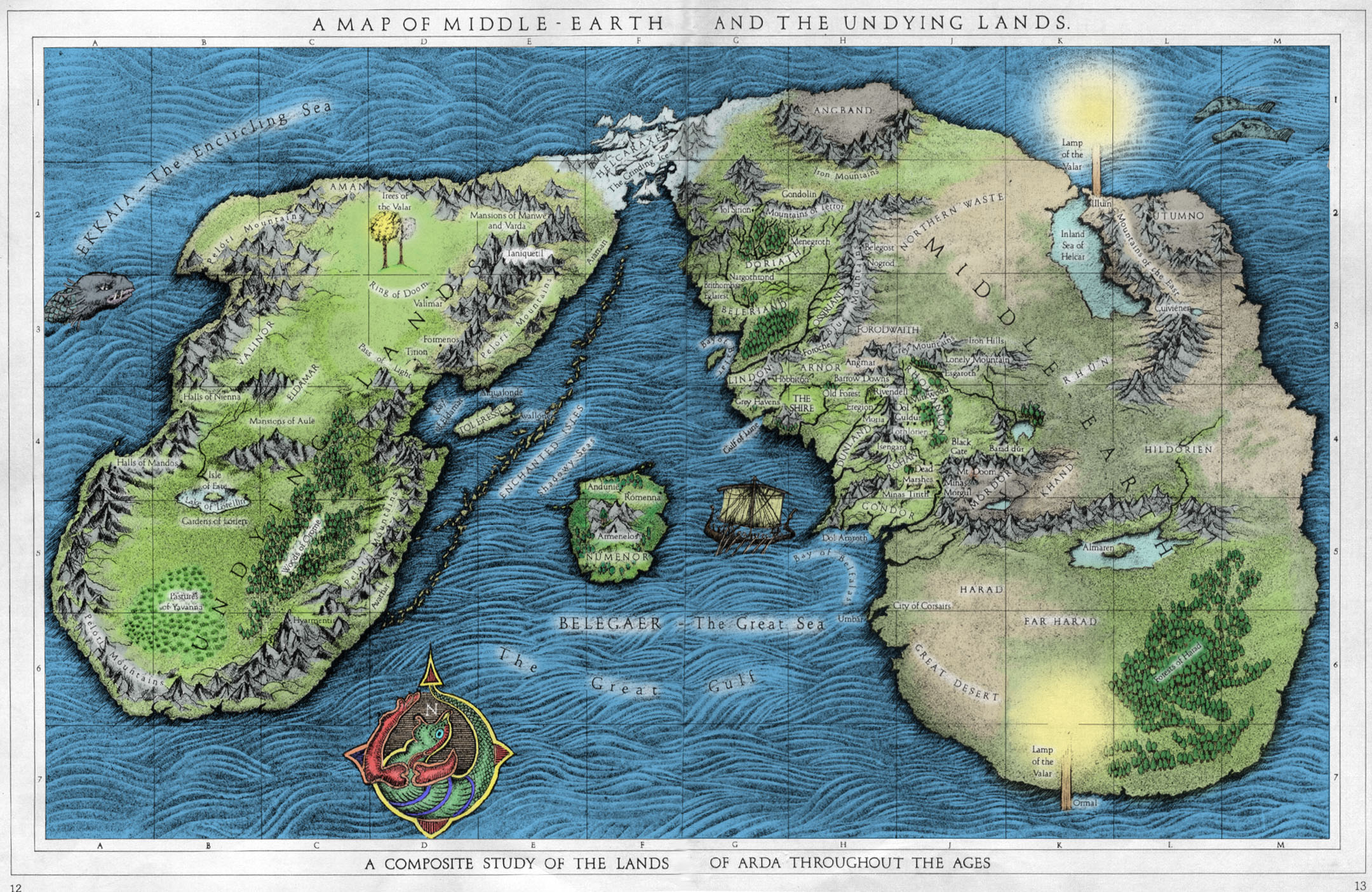
Last edited by Krieglord; February 21, 2013 at 10:04 AM.
Tip: don't bother to use that map to make up your mind on Arda (Earth).
It mixes the Ages and I can't even guess what material it is based on, it look like a map on loads of fan fiction EDIT: while the places themselves AFAIK all exist their positions are not reliable
Edit: dunno if you saw it but otherwise you have a bunch of Avari-quotes on last page
Last edited by Ngugi; February 21, 2013 at 10:12 AM.
Kingdom of Lindon preview video out
DCI: Last Alliance - WIP Second Age mod | DCI: Tôl Acharn - mighty Dúnedain Counter Invasions |
Additional Mercenary Minimod - more mercs; for TATW and DCI | Family Tree minimods - lore improvements | Remade Event Pictures - enhance cultures trough images |
Favorite TATW compilation: Withwnars Submod Collection
Patron of Mank, Kiliç Alì, FireFreak111, MIKEGOLF & Arachir Galudirithon, Earl of Memory
Well I was using it more for trying to get an understanding of the geography of middle earth pre 3rd age then anything although yes probably based on fan fiction more then anything I read tolkien did draw a map but I cant find it online (copyright issues I assume) and don't know if it is 3rd age or pre 3rd age.
And oh thanks for pointing that out I may not have looked you certainly are quick with the quotes their thanks for the information +rep
there be an army of malign ferrets feeding him quotes so that he can eventually rise up as a new dark lord to take over arda!!!
or didn't you know that
but as always bow before the lore master
We really are down to three maps. The LotR map, the Beleriand map in Silmarillion (which is Christoper's clean drawing based on Tolkien's second and very edited Beleriand map, found in HoME 11) and the only world map Tolkien made a sketch of (from HoME 5):
Spoiler Alert, click show to read:
However it was made in the 1920ths, least I find it obsolete and it is also questioned by Christopher even if not dismissed.
Obviously in such matters as that the misty Mountains do not exists on it, it contain areas never mentioned again, the Sea of Helcar has a questionable position etc.
I find it uninteresting because Tolkien never updated it and that I belive was because he wanted it to be obscure: if the Elves and Dúnedain did not know or least passed down tha maps, then no one now will know due to lack of sources.
But if to form a mental map it is those three that should be used (beside any useful written directions, which are not to many)
@ both gent's
Glad to help
Last edited by Ngugi; February 21, 2013 at 10:47 AM.
Kingdom of Lindon preview video out
DCI: Last Alliance - WIP Second Age mod | DCI: Tôl Acharn - mighty Dúnedain Counter Invasions |
Additional Mercenary Minimod - more mercs; for TATW and DCI | Family Tree minimods - lore improvements | Remade Event Pictures - enhance cultures trough images |
Favorite TATW compilation: Withwnars Submod Collection
Patron of Mank, Kiliç Alì, FireFreak111, MIKEGOLF & Arachir Galudirithon, Earl of Memory
For what it's worth, the most convincing map I've seen of how Middle Earth evolved from the first to second ages is found here.
I until recently found that credible too, but considering the described climates and vegetations I do no longer.
Beleriand has to be moved quite a bit south or Hithlum, Angauglith and Lothlann would been tundra, not green fields that can sustain, in Hithlum's case, great populations.
Kingdom of Lindon preview video out
DCI: Last Alliance - WIP Second Age mod | DCI: Tôl Acharn - mighty Dúnedain Counter Invasions |
Additional Mercenary Minimod - more mercs; for TATW and DCI | Family Tree minimods - lore improvements | Remade Event Pictures - enhance cultures trough images |
Favorite TATW compilation: Withwnars Submod Collection
Patron of Mank, Kiliç Alì, FireFreak111, MIKEGOLF & Arachir Galudirithon, Earl of Memory
LOL ^^
Kingdom of Lindon preview video out
DCI: Last Alliance - WIP Second Age mod | DCI: Tôl Acharn - mighty Dúnedain Counter Invasions |
Additional Mercenary Minimod - more mercs; for TATW and DCI | Family Tree minimods - lore improvements | Remade Event Pictures - enhance cultures trough images |
Favorite TATW compilation: Withwnars Submod Collection
Patron of Mank, Kiliç Alì, FireFreak111, MIKEGOLF & Arachir Galudirithon, Earl of Memory
A glaring mistake on that map is the fact that Numenor is not star shaped.
Were there but a tree in this godforsaken place i would have hanged myself.
Hm. At the same time, let's not discount the possibility that the drowning of Beleriand brought with it significant changes in climate, with Middle-Earth becoming colder. The idea sounds like something Tolkien might have approved of, the world cooling with the passing of the grandeur of the First Age.
At the same time, there are a couple of sites which pop up on both maps which play pretty well into the one I posted above. The Ered Luin are of course the most obvious, which more or less confirms my map (unless you want to argue that the blue mountains drastically changed their shape, which, while not impossible, is no more improbable than my climate change theory .) We can also look at the placement of Himring, Maedhros's old fortress, which stood to the west of the Blue Mountains in the First Age and supposedly stood a few dozen miles off the coast of Lindon in the Second Age, which also seems to confirm the map I posted.
I get that the climate is an issue, but I'm not convinced that there's a better portrayal of the way the maps changed between the first and second ages...
a better portrayal no.. a totally accurate map existing may also be a no
now lets observe quietly as the ferret eats his argument alive
Last edited by knight of meh; February 21, 2013 at 11:56 AM.
I think only J.R.R knew what he wanted Arda to look like and he never had the good graces in his later years to take up cartography once more...
@ Garriath
True, though the Mountains must have moved weither one like 'your' or 'my' theory, as your posted map do not match with Harlindon's mountains.
Had to look into the Hitlum matter to be sure - which proved to provide me with a lost piece of argument hehe.
Actually, if you look at where island is, you would find it do support the idea of moving Beleriand a bit south where, or the island is in wrong place; which to me support the thought of the 2nd/3d Age Ered Luin's northest eastturn to correspond with the 1st Age east-turn.
See red ring for the fort and yellow for where the island is:
Spoiler Alert, click show to read:
@ knight of meh
Haha, I am humbly aware that I am wrong both now and then; that's good so one don't get hybris ^^
Last edited by Ngugi; February 21, 2013 at 12:09 PM.
Kingdom of Lindon preview video out
DCI: Last Alliance - WIP Second Age mod | DCI: Tôl Acharn - mighty Dúnedain Counter Invasions |
Additional Mercenary Minimod - more mercs; for TATW and DCI | Family Tree minimods - lore improvements | Remade Event Pictures - enhance cultures trough images |
Favorite TATW compilation: Withwnars Submod Collection
Patron of Mank, Kiliç Alì, FireFreak111, MIKEGOLF & Arachir Galudirithon, Earl of Memory
Digging around, I think I've got something interesting.
Seems to me that there are two important points to take away here:22 These are a strange, unfriendly people, remnant of the Forodwaith, Men of far-off days, accustomed to the bitter colds of the realm of Morgoth. Indeed those colds linger still in that region, though they lie hardly more than a hundred leagues north of the Shire.
-Appendices, The North-Kingdom and the Dunedain
1. It establishes that the Shire was really quite far north, and close to the ruins of Angband. This seems to support Nguigi's point that Beleriand should be moved south, or somehow pivoted, say, 30 degrees to the left.
2. It seems to advance the argument that how cold an area is has much more to do with its history than it does with its geographic location (that is, Morgoth's lands have remained cold, even though a much warmer climate in the Shire is quite nearby. Therefore, Hithlum's northern location wouldn't necessarily have meant that its climate was dramatically cold.
Edit: eep. Ninja'ed. Yeah, I'll concede that Beleriand ought to be moved a bit south, though I think we can agree that the map's the best we have, and a tad better than the one posted before .
Last edited by Garriath; February 21, 2013 at 12:11 PM.
well yea but i witnessed you pick apart that map before can't remember were might have been the DaC or war of the simarilis (yea it's prob spelled wrong i'm tired ) thread...i think
so i thought it was a safe bet that you still remembered that debate
oh and it's hubris that refers to an arrogant attitude , i don't usually correct peoples spelling grammar and or syntax but it took me 5 mins to work out what you meant
a hundred leagues is 550- 560 Km if my memory serves me which is quite far actually if you travel by pre-modern methods.
Last edited by Beorn; February 21, 2013 at 12:45 PM.
Won't battle you on the latter
Actually was I who brought in and defended that map in the Dac thread haha, but in general a confusing argumentation, don't remember on what sides I was when; ended up not accepting in either way xD
Hybris? bah! That's perfect Swedish spelling
Last edited by Ngugi; February 21, 2013 at 03:25 PM.
Kingdom of Lindon preview video out
DCI: Last Alliance - WIP Second Age mod | DCI: Tôl Acharn - mighty Dúnedain Counter Invasions |
Additional Mercenary Minimod - more mercs; for TATW and DCI | Family Tree minimods - lore improvements | Remade Event Pictures - enhance cultures trough images |
Favorite TATW compilation: Withwnars Submod Collection
Patron of Mank, Kiliç Alì, FireFreak111, MIKEGOLF & Arachir Galudirithon, Earl of Memory