Nice work so far, you have to continue with this!
Also I dont know if you guys have opened those spline files already, but if somebody could extract such a file and upload it here I'll try to open it in 3DS Max.


")


It is easy to extract all files with Pack File Manager but 3DS Max cannot open these spline files.


All of these regions are on the GC map though some are hidden, such as the Chinese Empire. I said that they were unplayable because armies can't move across them.Originally Posted by Rizz

Can 3DS Maxopen rigid_mesh files?
Morning Sun (adds Korea and China to the Shogun 2 map)
http://www.twcenter.net/forums/forum...28-Morning-Sun
Expanded Japan mod (97 new regions and 101 new factions)
http://www.twcenter.net/forums/showt...ew-factions%29
How to split a region in TWS2
http://www.twcenter.net/forums/showt...split-a-region
Eras Total Conquest 2.3 (12 campaigns from 970-1547)

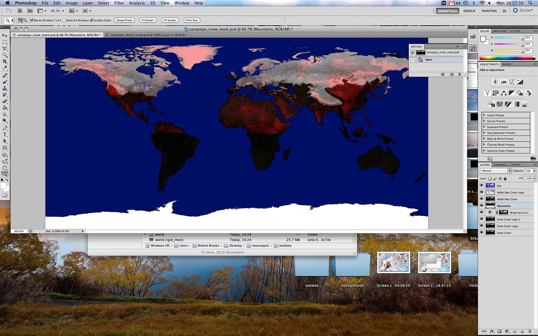
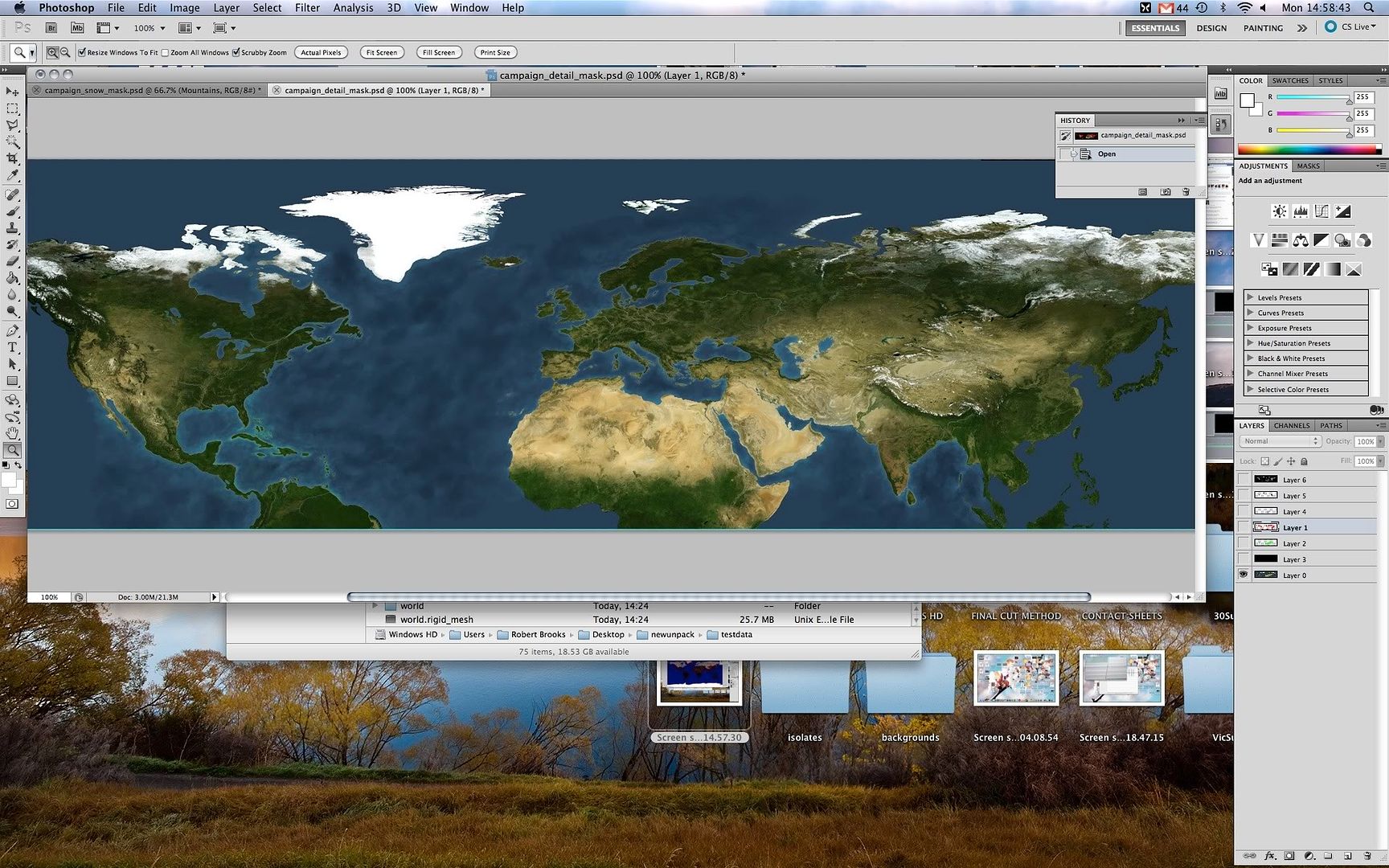
Has anyone else taken a look at the testdata.pack file? I extracted it and there's a lot of interesting stuff in there. They seem to have even left PSD files in there, with all the layers intact. The 2 I have looked at are of the world map. The whole world always there, in a lot of the layers it goes from central Africa and up, there is no detail below that line. There are density maps for trees that look they they've been made in MS paint and also a cloudmap. It's all interesting stuff, but I'm not sure it will be helpful. I can't find any kind of lookup.tga file anywhere. There's also a lot of rigid_mesh files, town.rigid_mesh, westerneuborders.rigid_mesh and world.rigid_mesh all sound worth investigating, but I don't know what application to open them with. Looking at one of the campaign xml files, the regions of Timor, Bali, Burma, and some other south east asian regions are mentioned, presumably CA were originally going to have to have it more than just a trade theatre. There is a folder called splines, which contains numerous rigid_splines files including ones titled wallborderspline and world. Perhaps worth investigating in further detail, even if it isn't particularly useful?
If you look at the layers tab in the bottom right hand corner you will see what I mean:
Spoiler Alert, click show to read:
Spoiler Alert, click show to read:
There are also a lot of flags that weren't used in the game (swiss confederacy and tuscany for example)
I learnt that two files I extracted from the supertexture pack called world_.stpi and world_.stpd should in theory be able to open using a CAD programme.
Apologies if what I've posted has been posted before.
Does anyone know how to extract the files in the ESF files that aren't just tables and stuff? Can I use ESF editor do this?
Last edited by toxicpiano; May 17, 2010 at 04:31 PM.
I don't think the testpack is actually used in ETW. Though it does contain some useful files, such as the coast.rigid_mesh which shows how all the coastline files fit together. This file is tilted as the program I used to view the rigid_mesh can't zoom in on specific areas.
Spoiler Alert, click show to read:
Morning Sun (adds Korea and China to the Shogun 2 map)
http://www.twcenter.net/forums/forum...28-Morning-Sun
Expanded Japan mod (97 new regions and 101 new factions)
http://www.twcenter.net/forums/showt...ew-factions%29
How to split a region in TWS2
http://www.twcenter.net/forums/showt...split-a-region
Eras Total Conquest 2.3 (12 campaigns from 970-1547)
")
So...
Has a way be found for someone to break up a region in a ETW theatre to two smaller ones?
Or add a town to a region? Or add a harbor?
alhoon is not a member of the infamous Hoons: a (fictional) nazi-sympathizer KKK clan. Of course, no Hoon would openly admit affiliation to the uninitiated.
"Angry Uncle Gordon" describes me well.
_______________________________________________________
Beta-tester for Darthmod Empire, the default modification for Empire Total War that does not ask for your money behind patreon.
Developer of Causa Belli submod for Darthmod, headed by Hammeredalways and a ton of other people.
Developer of LtC: Random maps submod for Lands to Conquer (that brings a multitude of random maps and other features).


Have you guys considered comparing the napoleon land and coastlines.rigid_mesh and seeing how they differ?


Very interesting. POI = Points Of Interest? This is what I guessed when I browsed around the file a bit. By the way, the big map is 2^20 * small map
Anyhow, the borders in the game are defined using rigid splines. Each region defines its own borders as a sequence of points, which are saved as .rigid_spline files and stored in models.pack/rigidmodels/campaignborders. The same is true for roads and rivers. Not sure about bridges, they use a different method.
The height map is in the main pack.
The main hurdle for me is not editing the map but editing the .esf files because they contain so many cross-links and stuff that you can barely isolate anything and we don't know what many of the things do.
No thing is everything. Every thing is nothing.
I was wondering how they got this number. Though technically the small map is big map / 2^20 as the big map only has whole numbers while the small map has decimals.
*punches self in the face*Anyhow, the borders in the game are defined using rigid splines. Each region defines its own borders as a sequence of points, which are saved as .rigid_spline files and stored in models.pack/rigidmodels/campaignborders. The same is true for roads and rivers. Not sure about bridges, they use a different method.
I thought that this pack only contained unit models, I never thought it would also contain the regions' borders. Well that explains how each the border of each region is determined.
Also patch2.pack contains all the Warpath regions. They're in the rigidmodels/campaignroads/native folder.
Do you know why some regions such as Egypt have multiple rigid_spines?
I know. I'll add it to the first post.The height map is in the main pack.
I've been looking through a lot of the region.esf entries and I think I understand what most of the things do. Though I don't know as much about the startpos.esf.The main hurdle for me is not editing the map but editing the .esf files because they contain so many cross-links and stuff that you can barely isolate anything and we don't know what many of the things do.
Morning Sun (adds Korea and China to the Shogun 2 map)
http://www.twcenter.net/forums/forum...28-Morning-Sun
Expanded Japan mod (97 new regions and 101 new factions)
http://www.twcenter.net/forums/showt...ew-factions%29
How to split a region in TWS2
http://www.twcenter.net/forums/showt...split-a-region
Eras Total Conquest 2.3 (12 campaigns from 970-1547)
Well (judging by napoleon only, may be different in empire) im pretty sure that the splines do not go round the coasts as those are predefined as borders anyway but only sperate bits of land. The countries with multiple spleens have their borders seperated by coastlines e.g where france borders spain and where it borders the rest of europe or where england borders wales and scotland.
Also the splines should be in theory hex editable, its just a case of editing the right values. Alpaca did 'semi offer' to make a text converter but i think he forgot.
http://www.twcenter.net/forums/showthread.php?t=341425
Last edited by The Hedge Knight; May 22, 2010 at 08:29 AM.
A spline is a line from point a to point b. I guess that for visual reasons, CA didn't make borders go along the coast but only between provinces. You'll notice that landlocked provinces often only have one spline that goes in a topological circle, i.e. the last point equals the first or is very close to it. If a province has multiple splines that means it has multiple single border lines. France, for example, would have at least one in the Pyrenees and one in the east (could be three depending on whether they added an additional one for the Lac Génève).
Yes, thanks for reminding me. It's up in the NTW tools section.
Edit: By the way, any thoughts on pathfinding?
Last edited by alpaca; May 22, 2010 at 08:36 AM.
No thing is everything. Every thing is nothing.
Regarding pathfinding the Poi.esf seems to tell ETW where every area / region is in relation to everywhere else and even when there are no nearby regions. Each entry has a coordinate, the region the coordinate is in, nearby regions, and a number that I believe is a distance. At the end it lists the shortest distance between the coordinate and a nearby region.
However I don't know what the coordinates in this file mean as they don't seem to be for a region's border or a settlement. husserlTW tried giving a unit Poi coordinates to see where they would be on the map but it's unclear what they represent.
http://www.twcenter.net/forums/showt...99#post7305699
Morning Sun (adds Korea and China to the Shogun 2 map)
http://www.twcenter.net/forums/forum...28-Morning-Sun
Expanded Japan mod (97 new regions and 101 new factions)
http://www.twcenter.net/forums/showt...ew-factions%29
How to split a region in TWS2
http://www.twcenter.net/forums/showt...split-a-region
Eras Total Conquest 2.3 (12 campaigns from 970-1547)
There's a kind of "snapping" behaviour when you plan movement: The movement path will go through some point and if you move the target a bit, the army will change its path by a fair bit. This is a shot in the dark but maybe the POI coordinates are the coordinates of the anchor points for the movement paths and this represents a switch from one POI to the next? I could also imagine that it tells the AI where to when they try to move from a settlement to the next or something.
For some more analysis:
I think the very first number in POI is the number of points. What I think is a point entry looks like this:
Code:0 8 False -390594560 -159907840 0 0 0 0 -1 0 0 0 FalseCode:1 8 False -311951360 -169738240 0 0 0 0 -1 0 0 1 FalseCode:39 5 False -366215168 -118226944 eur_portugal 44 eur_portugal 44 17.95853 2 eur_atlantic_ocean_n 7.071068 eur_spain 19.5 7.071068 0 0 0 TrueThe first UInt I think has to be the point ID since it increases by one for each entry. No idea about the next one or the bool. The two large Ints are probably the coordinates for the point.Code:44 5 False -291766272 -159645696 eur_spain 33 eur_spain 33 41.81971 9 eur_navarra 63.20008 eur_catalonia 47.37616 eur_atlantic_ocean_n 46.67173 eur_balearic_sea 42.15744 eur_bay_of_biscay 82.1736 eur_alboran_sea 6.576473 eur_gibraltar 28.50438 eur_portugal 46.8855 eur_mediterranean_sea 12.20656 6.576473 0 0 0 True
Then seems to be an entry about which province the point is in, if applicable (Unicode + UInt but the UInt appears to change sometimes, Spain has 33 and 32). The float that looks a bit special could be the distance to the province capital, the center of the province, or something else entirely (it also has the province info, mind). The floats could be distances as you say with the UInt before them telling the game how many links the entry has. Then a last float for what?
Then three UInts and finally a float I have no ideas about.
No thing is everything. Every thing is nothing.
In the 'STARTPOS.ESF analysis and modifications. HYBRID startpos.esf' thread I posted my research on the esf files.
regions.esf
http://www.twcenter.net/forums/showt...27#post7220527
http://www.twcenter.net/forums/showt...65#post7296965
poi.esf
http://www.twcenter.net/forums/showt...68#post7227368
http://www.twcenter.net/forums/showt...60#post7233560
sea_grids.esf
http://www.twcenter.net/forums/showt...21#post7316121
Basically the Poi.esf works like this.
The first line of the POI.esf is how many entries it has. In the episodic map this is 463 (all of the America theatre).
Entries for playable neighbouring regions
These are the most common entries and are as follows:
These represent the following:Code:False 129 7 False -396623872 44826624 dutch_guyana 0 dutch_guyana 0 0 2 amazonas 24.45915 french_guyana 2.692582 2.692582 0 0 0
True or False (purpose unknown)
Position in POI (starts at 1 and increases every subsequent entry)
Number 1-8 (always a whole number)
True or False (purpose unknown)
World Position X Axis
World Position Y Axis
Sea / Region (dutch_guyana in the example)
Sea / Region ID
Sea / Region (dutch_guyana in the example)
Sea / Region ID
Number with decimal or 0 (purpose unknown)
Number of nearby regions or seas (in the above example there are 2)
Neighbouring Sea / Region (amazonas in the example)
Neighbouring Sea / Region ID (7 digits max)
Neighbouring Sea / Region (french_guyana in the example)
Neighbouring Sea / Region ID (7 digits max)
One of the Neighbouring Sea / region's number (french_guyana's in the example)
0
0
0
The 3 zeros signify the end of an entry.
Entries for non-playable neighbouring regions
These occasionally crop up. Most are at the end of the POI.esf.
FalseCode:False 426 7 False -368312320 455344128 greenland 105 greenland 105 0 0 -1 0 0 0
Position in POI
1-8 (always a whole number)
False
World Position X Axis
World Position Y Axis
Sea / Region
Sea / Region ID
Sea / Region
Sea / Region ID
0
0 (no neighbouring regions or seas)
-1 (no neighbouring regions or seas)
0
0
0
As there are no neighbouring playable regions the entry for the name of neighbouring regions and seas is replaced with a zero and the Neighbouring Sea / Region ID entry is is always -1. I'm guessing this is for regions at the edge of the map.
Entries for area without regions
These occur at the start of the POI.esf.
FalseCode:False 1 8 False -678952960 39321600 0 0 0 0 -1 0 0 1
Position in POI
1-8 (always a whole number)
False
World Position X Axis
World Position Y Axis
blank line (no region in this area)
0 (no region id)
blank line (no region in this area)
0
0 (no region id)
-1 (no neighbouring regions or seas)
0
0
Number of entries with no neighbouring regions (starts at 0 and increases every subsequent entry [skips 18, 36, and other multiples of 18])
Morning Sun (adds Korea and China to the Shogun 2 map)
http://www.twcenter.net/forums/forum...28-Morning-Sun
Expanded Japan mod (97 new regions and 101 new factions)
http://www.twcenter.net/forums/showt...ew-factions%29
How to split a region in TWS2
http://www.twcenter.net/forums/showt...split-a-region
Eras Total Conquest 2.3 (12 campaigns from 970-1547)
The entry starts with the ID, not with a bool, as you can see from the first entry. At least that's the case for NTW.
It's interesting to note that the three 0s aren't always 0. For example here's such an entry for Piedmont in NTW:
This means it's probably a set of 4 UInts all signifying a number of connections or something similar. The first is most frequently used but the second seems to exist at least once for each directly accessible neighboring region (i.e. you can get from this region to the other without going through another province), while the first one exists multiple times for each neighboring region, whether you can directly go there or not. Maybe the entry type where the second UInt is non-zero defines border crossings the AI can use?Code:411 3 True -132116890 -44979778 eur_piemont_liguria 4 eur_piemont_liguria 4 20.34959 0 -1 1 eur_northern_italy 5.611352 0 0 False
No thing is everything. Every thing is nothing.
I am almost sure that these numbers determines the length of common borders with neighbor regions. I say this examining (always) virginia. The closest maryland has far bigger number than pennsy or kentucky. The only things that suits analogically to these numbers-relations are the length of common borders.
In poi.esf only the settlement-capitol grids are present as in regions.esf. None of the rest grids are present in startpos or regions. Also in startpos only the settlement-capitol; grid are present in BDI which make it easy to spot. Pathfifinding.esf esf has many entries (I think more than BDI) but I searched some of them and they do not appear in startpos.
Alpaca, though I know you have not much free time, it would be crucial to make your startpos searching tool also for poi and pathfinding esf files.
Also any guess in answering these questions are welcome.
It should actually work for any .esf file, you just have to rename them to startpos.esf or point main.py to another file.
No thing is everything. Every thing is nothing.
Oh, sorry do you sink about PFM or some else for M2TW ?
Don't unpacker because hi don't import file in new pack.
Sooo.... how are things going, any new progress?
I'm going to assume not so much, cracking the map is a nearly impossible task.
"Close your eyes, Pray for Plagues"
 Posting Permissions


 Reply With Quote