Page 2 of 3 FirstFirst 123 LastLast
Results 21 to 40 of 55

Thread: Kilo11's Cartography Corner

  1. #21

    Default Re: Kilo11's Cartography Corner

    Quote Originally Posted by Lifthrasir View Post
    Interesting maps. I'd suggest to add a bit more contrast
    Quote Originally Posted by paleologos View Post
    Me too, I can hardly see anything, I thought the image wasn't loading properly.
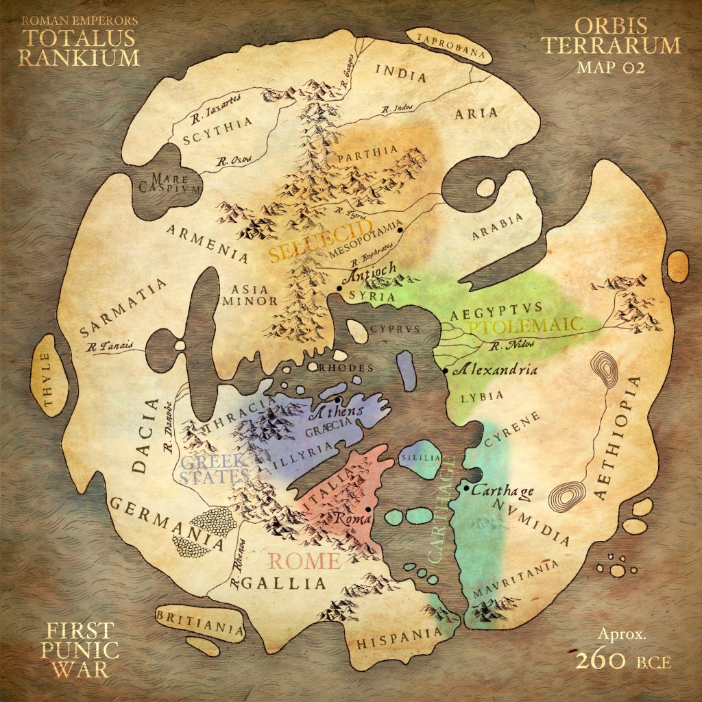
    Hmm. At first I thought it was just because that map is a lot larger than the other one, making the lines of the thumbnail harder to see (that is a part of it), but upon going back into the GIMP file and checking the colors and saturations, it is indeed a bit off. Thanks for the heads-up guys! I think it is because I was sick of clicking so many times to delete the color for each island or lake, leading me to just use color erase and go over everything with a huge brush, but I have just now found a much better way to go about things (will have to change the GIMP tutorial to reflect that). I think that this better method should also leave more darkness around things, making it easier to see the features of the land. If there is still an issue, I can always beef up the contrasts though.

    Given the new method (and the state of the GIMP files I now have saved), I think I will have to start from scratch on the new maps. It should be a bit faster now that I know better how to go about erasing things, but there will still be some delay. I'll let y'all know when the new files have been uploaded though. In the meantime I'll leave the low-contrast ones up, in case anyone finds them sufficient (but know that better ones are coming). Thanks again for catching my mistake guys!
    Last edited by Kilo11; November 20, 2018 at 08:05 AM.
    | Community Creative Writing
    | My Library
    | My Mapping Resources
    | My Nabataean AAR for EBII
    | My Ongoing Creative Writing

  2. #22
    Cookiegod's Avatar CIVUS DIVUS EX CLIBANO
    Citizen

    Join Date
    Aug 2010
    Location
    In Derc's schizophrenic mind
    Posts
    4,453

    Default Re: Kilo11's Cartography Corner

    Quote Originally Posted by Kilo11 View Post
    I think it is because I was sick of clicking so many times to delete the color for each island or lake, leading me to just use color erase and go over everything with a huge brush, but I have just now found a much better way to go about things (will have to change the GIMP tutorial to reflect that). I think that this better method should also leave more darkness around things, making it easier to see the features of the land.
    It sounds to me like you're making the mistake of not separating land and sea into separate layers. You should always keep them separate, so you can play around with them in the same manner. Minimum requirement is one layer with either ALL land OR all sea in it. Then all you have to do is go there, right click on layer, select all from alpha, then activate the layer where you want to change stuff, perhaps use CTRL+I to invert selection from land to sea or vice versa. IN the selection, you can do what you like.

    • If the color is in one contiguous area you can select the paint can, change the "Bucket Fill" mode to "color erase", and then just click the area with that color. Voila! That color is gone!
    • If the color is spread between many small areas (consider trying to erase the green from every island in the Aegean ) you can select the pencil, change it's mode to "color erase", and then just go over everything with it. If using this method it can be helpful to make the pencil have a hardness of 100 (prevents fuzzy edges to the erasure) and to make it have a huge size, reducing how much you need to swing it back and forth. Importantly, make sure you stroke across every inch of the canvas if using this method!!! Some colors will be components in other ones (erasing green can take a certain hue out of blue) and so erasing inconsistently will leave odd shadows that will be persistent later. ERASE EVERYTHING!
    When you have many small separate areas (e.g. by using the select from alpha option), you don't have to use a brush for that, but can just as well press shift whilst using the bucket tool.

    Truth be told, I have never used the colour erase tool, at least not through pencil or bucket tools. My way of doing that is to change colour to alpha through the colour tab for the entire layer very early on and make sure that shading, colouring, and various geographical features are in separate layers, so that if I want to change one thing, it won't conflict with the others. This way I evade most of the problems that can happen later on, and have apparently happened to you.

    Quote Originally Posted by Cookiegod View Post
    From Socrates over Jesus to me it has always been the lot of any true visionary to be rejected by the reactionary bourgeoisie
    Qualis noncives pereo! #justiceforcookie #egalitéfraternitécookié #CLM

  3. #23

    Default Re: Kilo11's Cartography Corner

    @Cookiegod: All of your points are things I have just learned, and I will change the GIMP guide to reflect that. The land layers (one for hillshading, one for topography) are separate from the sea one (one layer for bathymetry) but the original images you get off of DEMIS have land and sea colored in no matter what. I hadn't yet figured out a nice easy way to alpha out the unnecessary bits, but I just discovered the "Select By Color" tool (Shift+O), so now I just use that, select the unwanted color for the whole layer using that, and simply hit Delete. By just playing around with that and Color To Alpha, I think they amount to the same thing in the end, with about the same amount of work, but Color to Alpha allows for more subtle transitions and changes. Given that, I will explore that tool more before making changes to the above guide.

    I think that getting the hillshading right works better with color erase and the pencil tool though, as it gives a more smooth final product.

    At any rate, I am figuring things out bit by bit, and am still learning much with each map I make, so there will certainly need to be changes to the guide (and to my own methodology). Given that, if you or anyone else has pointers or thoughts, do share them! As I said in the OP, I am certainly doing some things by foolishly overworked brute force when there are easier ways to go about it.
    | Community Creative Writing
    | My Library
    | My Mapping Resources
    | My Nabataean AAR for EBII
    | My Ongoing Creative Writing

  4. #24
    Cookiegod's Avatar CIVUS DIVUS EX CLIBANO
    Citizen

    Join Date
    Aug 2010
    Location
    In Derc's schizophrenic mind
    Posts
    4,453

    Default Re: Kilo11's Cartography Corner

    remember that you can toggle the sensitivity of the select by colour tools (there are two of them btw., one that only applies to one spot and one that applies to the entire layer) simply by holding your mouse and dragging it up and down. This tool might be the one I use the most. Also, the select colour (the one where you get the colour where you point at) tool is also included in the pencil (N), so if you hold CTRL whilst clicking it selects colour. That's how I trigger it.

    Another thing I'd like to mention is how insanely laborous my way of making rivers from paths was. So I'm not sure if it's the right way to do it for you. On the other hand, once you've done it it makes it so much easier for you to change things afterwards. As I've switched to a graphics tablet, I've really been dumbfounded by how much easier it is to simply draw the rivers by hand is. I put a picture in the folder I sent you per mail that shows you the right path (harr harr) if you want to try my old method out.
    I think it's a smart move that you work on a large map, so should you ever switch from one map to one that partly overlaps with it, you don't have to do that part of the map again.
    E.g. your Greater Greece map overlaps with that of Arabia.

    Quote Originally Posted by Cookiegod View Post
    From Socrates over Jesus to me it has always been the lot of any true visionary to be rejected by the reactionary bourgeoisie
    Qualis noncives pereo! #justiceforcookie #egalitéfraternitécookié #CLM

  5. #25
    Cookiegod's Avatar CIVUS DIVUS EX CLIBANO
    Citizen

    Join Date
    Aug 2010
    Location
    In Derc's schizophrenic mind
    Posts
    4,453

    Default Re: Kilo11's Cartography Corner

    Some awesome maps I found recently for inspiration:
    https://totalusrankium.wordpress.com/orbis-terrarum/
    https://totalusrankium.wordpress.com...nd-birth-maps/
    Spoiler Alert, click show to read: 


    EDIT: Also this one: https://easyzoom.com/imageaccess/ec4...9c14156bb6836f
    Last edited by Cookiegod; December 13, 2018 at 02:56 PM.

    Quote Originally Posted by Cookiegod View Post
    From Socrates over Jesus to me it has always been the lot of any true visionary to be rejected by the reactionary bourgeoisie
    Qualis noncives pereo! #justiceforcookie #egalitéfraternitécookié #CLM

  6. #26

    Default Re: Kilo11's Cartography Corner

    Those are super cool Cookiegod! I will add them to the OP the next time I make an update here. And I was feeling like adding something here anyway, so this morning I have been getting everything together for starting on a grand map of the entire campaign area. It will be something unreasonably massive, but then people can just use cutouts of the areas that are of interest to them for their own purposes. Hopefully later today I can start stitching the panels together and then get it mostly done over this weekend.
    | Community Creative Writing
    | My Library
    | My Mapping Resources
    | My Nabataean AAR for EBII
    | My Ongoing Creative Writing

  7. #27
    Swaeft's Avatar Drama King
    Content Emeritus

    Join Date
    Nov 2012
    Posts
    2,307
    Blog Entries
    8

    Default Re: Kilo11's Cartography Corner

    Hello Kilo11,

    First off let me say that this is lovely, noble effort that you are undertaking here. As an AAR writer myself, I agree that map templates or base maps are hard to come by, especially ones of quality such as yours. Thank you for doing such a great service for the rest of us. The tutorials are well explained, and are very much appreciated. You have clearly put a lot off effort into them and I hope that others can see that.

    For comments about the maps: The Magna Italica map looks good. At first I was wondering why everything was white (silly me), then I read the other comments and also realized that it's meant to be a template. For the Terrae Graeciae map, I have to inform people that it does look like it needs more contrast, but that's because it's a 2K map that's condensed to fit the site. If you expand it it's actually fine.

    Great work as usual, Kilo11!

    Swaeft's Scribblings (Library)| Swaeft's Snaps (Gallery)| My Blog (The Lensation)

  8. #28
    Skotos of Sinope's Avatar Macstre Gaposal
    Join Date
    Sep 2017
    Location
    The Republic of Letters
    Posts
    789

    Default Re: Kilo11's Cartography Corner

    Kilo's Magna Italica maps rock. Just used them to create my AAR map of Etruria:

    Spoiler Alert, click show to read: 


    Combined with Google Earth, and by looking up all the ancient cities in relation to modern ones, I was able to finally create the historically accurate map I wanted. Really grateful for Kilo's hard work on this project. By the way K, have you ever been to this site? I stumbled upon it when I was looking up reference maps. Seems right up your alley.

  9. #29

    Default Re: Kilo11's Cartography Corner

    @Swaeft: Thanks, and I do hope you are able to make use of one of the maps. Right now I am working on a grand map that is huge, and will hopefully have that out at some point in the not too distant future. The idea with that one is to cover all of the Magnus Mundus area of the European theatre TW games, at a large enough scale that people can just cut it to the area that interests them and have it still be quality. But we'll see.

    @Skotos: I didn't realize you used my map as a base for this, but that is really cool to hear! Would you actually mind if I put your map in the OP here, as an example of how one can take the templates and flesh them out for one's own purposes? I mean, that was my intent anyway, as what I have here is not really pretty or fully-fledged, but really just the basics of maps for others to then build on. It would be nice to showcase how well these templates can be put to use!

    That site is AWESOME!!! And now I have something else to keep me from getting work done. After seeing that site and reading your guys' posts, I think I will need to do some mapping today! Oh, and would you (or anyone else reading this) be interested in seeing some hand-drawn maps I made a while back for a fantasy novel series I'm working on (it's on hold right now though, so don't expect to see any of the actual writing)? They're super detailed, with forests, mountains, rivers, swamps, etc., sort of modeled after the big fold-out map that is in the front of the Lord of the Rings.
    | Community Creative Writing
    | My Library
    | My Mapping Resources
    | My Nabataean AAR for EBII
    | My Ongoing Creative Writing

  10. #30
    Araval's Avatar Protector Domesticus
    Join Date
    Nov 2010
    Location
    Tartu, Estonia
    Posts
    4,754

    Default Re: Kilo11's Cartography Corner

    Quote Originally Posted by Kilo11 View Post
    Oh, and would you (or anyone else reading this) be interested in seeing some hand-drawn maps I made a while back for a fantasy novel series I'm working on (it's on hold right now though, so don't expect to see any of the actual writing)? They're super detailed, with forests, mountains, rivers, swamps, etc., sort of modeled after the big fold-out map that is in the front of the Lord of the Rings.
    Sure thing!

  11. #31
    Skotos of Sinope's Avatar Macstre Gaposal
    Join Date
    Sep 2017
    Location
    The Republic of Letters
    Posts
    789

    Default Re: Kilo11's Cartography Corner

    Quote Originally Posted by Kilo11 View Post
    @Skotos: I didn't realize you used my map as a base for this, but that is really cool to hear!
    Yeah dude. Remember, you tried sending them to me first as GIMP files, and I then pestered you by email for about a week with questions. I basically just zoomed in and traced over the Magna Italica maps. (The coast lines, the mountains and rivers/lakes. All from those respective maps) The only thing I had to figure out was getting Google Earth maps to line up, which was tough because of the different projections that you said they use. But what's cool about what you've done is that it gives you an initial frame of reference that you can fit other stuff in. So all I had to do was use the free transform tool in photoshop and distort it until the Google map landform features matched the MI maps and I was good to go. It may not sound like a big deal until you actually go out there and google different maps and then try to make it all line up on your own. I would have been stumped doing this all on my own.

    Quote Originally Posted by Kilo11 View Post
    Would you actually mind if I put your map in the OP here, as an example of how one can take the templates and flesh them out for one's own purposes? I mean, that was my intent anyway, as what I have here is not really pretty or fully-fledged, but really just the basics of maps for others to then build on. It would be nice to showcase how well these templates can be put to use!
    Go ahead. So long as you promise to update it with the finished version when that's done. I still want to correct a couple of boo-boos, add a legend and at least the Ciminian Forest.

    And yeah, I second Araval in wanting to see some hand drawn maps. (Personally, I like looking at maps a lot more than I like making them.)
    Last edited by Skotos of Sinope; January 08, 2019 at 07:54 PM.

  12. #32

    Default Re: Kilo11's Cartography Corner

    Cool. I think I'll put the image in a contentbox under the "Usage" section then, to show people how these base maps can be used to make something great (your map really is awesome!).

    And here are two maps I made for a longer work of fiction I've been working on for a while now. Be gentle, as they need to be redone in digital form, starting with a new, higher-quality scan of the originals, but my wife had them framed so I'd first need to take them out. At any rate, the idea I have for them is for each map to cover the whole side of a paperback page (you know, as a map for the book that takes place in that region), and for those purposes, they are more than adequate.

    Maps: Kingdom of Dorian + Kingsport


    The Kingdom of Dorian


    The City of Kingsport (inset from the above map)

    Last edited by Kilo11; January 09, 2019 at 02:02 AM.
    | Community Creative Writing
    | My Library
    | My Mapping Resources
    | My Nabataean AAR for EBII
    | My Ongoing Creative Writing

  13. #33
    Araval's Avatar Protector Domesticus
    Join Date
    Nov 2010
    Location
    Tartu, Estonia
    Posts
    4,754

    Default Re: Kilo11's Cartography Corner

    Looks great and I bet even better when digitally remade. Some text is a bit hard to read at the moment, something to keep in mind when thinking on a paperback page.

  14. #34
    Skotos of Sinope's Avatar Macstre Gaposal
    Join Date
    Sep 2017
    Location
    The Republic of Letters
    Posts
    789

    Default Re: Kilo11's Cartography Corner

    Quote Originally Posted by Araval View Post
    Looks great and I bet even better when digitally remade.
    Agreed. And on the subject of working digitally, get yourself a vector-based graphics design program like Adobe Illustrator, k. Everything is so much easier when it's all vector-based. And if even I can bust out something half-decent using it, then that means you'll be flying.

  15. #35

    Default Re: Kilo11's Cartography Corner

    But don't you have to pay for the Adobe Illustrator program you're using? In theory, I totally agree with you about the value of using vector-based programs, but I also like the value of free programs. At any rate, you have convinced me to a fair degree already, and I'm mulling over the possibility. Maybe I'll take a couple weeks vacation at some point so that I can get really into mapping, and at that time get a trial month of Illustrator or something and just go nuts. I fear that if I get it now, I will pay a monthly fee and only rarely use it, since I'm so swamped with actual work and trying to fit in writing time between all that.
    | Community Creative Writing
    | My Library
    | My Mapping Resources
    | My Nabataean AAR for EBII
    | My Ongoing Creative Writing

  16. #36
    Skotos of Sinope's Avatar Macstre Gaposal
    Join Date
    Sep 2017
    Location
    The Republic of Letters
    Posts
    789

    Default Re: Kilo11's Cartography Corner

    Yeah, do the trial when you get some time off. During which I can send you the video tutorial I used, and you can learn that way. (I can also send you all the brushes, symbols and fonts I used.) You can get a 60% discount as a student. So that would be not just Illustrator, but also Photoshop, InDesign, etc. for less than $20. Trust me, you'll end up using them all. I'll PM you the details, because right now I'm pretty sure I'm skirting the forum rules on spamming. (I don't work for Adobe, I swear!)

  17. #37
    Lifthrasir's Avatar "Capre" Dunkerquois
    Patrician took an arrow to the knee

    Join Date
    Jan 2010
    Location
    City of Jan Baert
    Posts
    13,950
    Blog Entries
    4

    Default Re: Kilo11's Cartography Corner

    Quote Originally Posted by Skotos of Sinope View Post
    (I don't work for Adobe, I swear!)
    Shame, we could have asked you for discounts

    @ Kilo11, keep it up Mate. Good job!
    Under the patronage of Flinn, proud patron of Jadli, from the Heresy Vault of the Imperial House of Hader

  18. #38
    cedric37's Avatar Why Not ?!
    Patrician Citizen

    Join Date
    Sep 2009
    Location
    France
    Posts
    8,573

    Default Re: Kilo11's Cartography Corner

    Nice work here, sorry I did not stop by before
    it has a real nice feeling, especially the hand drawn maps !
    Patronized by y2day/Patron of KDK, Swagger & Navajo Joe, of the Imperial House of Hader


  19. #39
    King Athelstan's Avatar The Wheel Weaves
    Join Date
    Sep 2013
    Location
    Nidaros
    Posts
    6,773
    Blog Entries
    8

    Default Re: Kilo11's Cartography Corner

    You make some mighty fine maps indeed, good work!
    Proudly under the patronage of General Brewster of the Imperial House of Hader
    Proud patron of 4zumi, Akar, CommodusIV ,Swaeft
    and Peaman


  20. #40

    Default Re: Kilo11's Cartography Corner

    Quote Originally Posted by Skotos of Sinope View Post
    Yeah, do the trial when you get some time off. During which I can send you the video tutorial I used, and you can learn that way. (I can also send you all the brushes, symbols and fonts I used.) You can get a 60% discount as a student. So that would be not just Illustrator, but also Photoshop, InDesign, etc. for less than $20. Trust me, you'll end up using them all. I'll PM you the details, because right now I'm pretty sure I'm skirting the forum rules on spamming. (I don't work for Adobe, I swear!)
    Quote Originally Posted by Lifthrasir View Post
    Shame, we could have asked you for discounts

    @ Kilo11, keep it up Mate. Good job!
    Quote Originally Posted by cedric37 View Post
    Nice work here, sorry I did not stop by before
    it has a real nice feeling, especially the hand drawn maps !
    Quote Originally Posted by King Athelstan View Post
    You make some mighty fine maps indeed, good work!
    @Lifth, cedric, and KA, thanks for the support! And I swear this endeavor is not dead! I have just been over-busy with other things and had to back-burner some things for a bit.

    @Skotos, I have had Adobe in mind since you told me about it, and I will definitely keep thinking about it. At the very least, if at any point I can actually start being an author as like my job, then I will get the programs you're using so that I can better play with images, maps, and pictures for my stories. Until then though, I think I will keep the $20 a month
    | Community Creative Writing
    | My Library
    | My Mapping Resources
    | My Nabataean AAR for EBII
    | My Ongoing Creative Writing

Page 2 of 3 FirstFirst 123 LastLast

Posting Permissions

  • You may not post new threads
  • You may not post replies
  • You may not post attachments
  • You may not edit your posts
  •