GeoMod saves those entries in the string.bin file NOT the txt file. You need to convert with this tool to get the updated txt file.


")

")
")
")

")


GeoMod saves those entries in the string.bin file NOT the txt file. You need to convert with this tool to get the updated txt file.
oki, thanks.
Work done:
1. Translated the source files (15) where nexessary, using Notepad++
2. Updated the globe icon for use with Vista, using IcoFX
Once the EXE has been compiled, please upload so I can create an installer again with all the English M2TW files.
Observations:
- Moving a resource on top of an existing one causes an error message and a PROGRAM FREEZE.
Thanks:
- This will take a few days out of mapping!
Danke schön.
Man tut was man kann


Thanks again for your help gigantus. New ico will be usefull for the original french version too.
Here is the link for the re-compiled english version : http://keonet.free.fr/Geomod/Geomodv0.2.3(english).zip
Oh be carefull, I think the M2TW files I put in the archive are still the french ones, just replace them with your own versions (particularly the "text" sub-folder).
Installer for GeoMod EN 0.23
README:
Installer for GeoMod ver 0.23 English
General:
I have taken the translated GeoMod upload provided by Octavius and have made the following changes\additions:
1. Replaced all files in the M2TW_files folder with the English versions
2. Extracted and converted icons from GeoMod and BinEditor for use with the installer
3. Put everything into this installer
Note:
Have a look in the M2TW_files folder to see which files the program needs. Explore the folder with the program to your heart's content.
Installation:
- The installer will automatically detect your installation of M2TW and then install the program into the M2TW\tools subfolder.
- Shortcuts for GeoMod and BinEditor will be put on the desktop

Great work gigantusI'm updating the first post.
Lol, you should add this one to your sigOriginally Posted by gigantus


Patronized by PowerWizard - Europe Total War - Wargame mod for M2TWwww.mundusbellicus.fr : the french total war forum
The English version:
One is glad to be of service
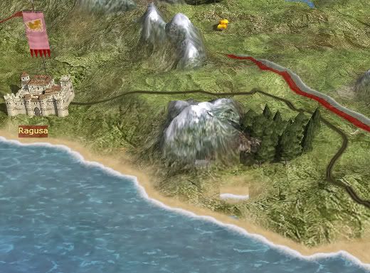
Hmm I screwed something up. It's very strange. To get the Retrofit map to run after using the Geomod Tool I had to remove the port from Ragusa or it would fail at creating the settlement. Instead, on the tile where the port USED to be, there is a shoreline tile.
The strange thing is, the closest provice I edited to where Ragusa is, is Warsaw! Nowhere near Ragusa!
How odd, I am going to have to work on this more since I can't afford a computer that can run Empire. Here's a picture:
Coordinate point for the coast tile btw, is 172, 92 (The Sea).
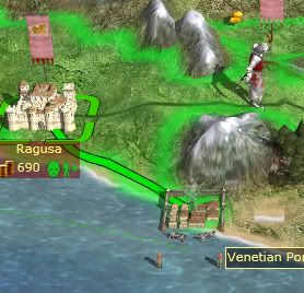
ED: I managed to mod the port back in but now the road won't connect to it. That's fine, I can still reach it, but I wonder if the trade will suffer some. It's a castle so it's no big deal but.... I'm still just starting mapping, anyone have any idea what file to look at to get rid of the shore tile where the port used to be?
Last edited by SSJPabs; March 15, 2009 at 10:58 PM.
Song of Victory: A Lithuanian's Tale - Last Update dJanuary 19!
Reconquista: An Iberian Romance AAR - Completed!
The Turks 2 (Crusade AAR, No Roleplay) - Completed!
The port of Ragusa is a known issue, the map_regions is not the version that was used to create the map.rwm file.
So don't feel bad and enjoy the modding!
Shoretile: in GeoMod switch to heights and then paint over the tile with water (blue)

")
Sinople, +rep for a great tool!
"If ye love wealth greater than liberty,
the tranquility of servitude greater than
the animating contest for freedom, go
home from us in peace. We seek not
your counsel, nor your arms. Crouch
down and lick the hand that feeds you,
and may posterity forget that ye were
our countrymen."
-Samuel Adams
Thanks, but the major rep goes to Octavius
Patronized by PowerWizard - Europe Total War - Wargame mod for M2TWwww.mundusbellicus.fr : the french total war forum
Hmm is the Jordan river another known issue? It got much wider and you can kind of see the smaller version.
Anyhow I am ADDICTED to this tool. I am making tons of tiny little adjusted to the strat map as well as making it almost too easy to make new regions. So thanks to both Sinople and Octavius.
Song of Victory: A Lithuanian's Tale - Last Update dJanuary 19!
Reconquista: An Iberian Romance AAR - Completed!
The Turks 2 (Crusade AAR, No Roleplay) - Completed!
Well, thanks SigniferOne and SSJPabs !
I am currently programming the next version of the tool, including the complete management of the characters (except the family tree).
That would be an error on the map_heights file. In GeoMod paint over that area with a setting of 1,1,1 - the original is zero,zero,zero which is water.Hmm is the Jordan river another known issue? It got much wider and you can kind of see the smaller version.
Standing by for translationI am currently programming the next version of the tool, including the complete management of the characters
FileFront is closing shop, so I moved the latest English version to RapidShare
GeoMod Tool 2.3 EN
I've noticed several changes (since I use the Reg Verde map and NOT Vanilla as my base) where there are points that look like land, but are actually water (that ships can float in and armies can't walk over) like near the Corinth and the Venetian regions so I am going to have to go over the map heights file carefully.
Thank you for the response--and for letting me know file front is dying!
ED:Hmm, when I open the map_heights file in GeoMod it shows other than 0,0,0. And the other areas where it shows land on the visual map but the tile reads "sea" are also painted over in both the Map Heights AND Map Regions. Obviously I am missing something.
ED ED: Oh I see now. I was reading Map_Heights wrong. Thank you.
Last edited by SSJPabs; March 27, 2009 at 07:59 PM.
Song of Victory: A Lithuanian's Tale - Last Update dJanuary 19!
Reconquista: An Iberian Romance AAR - Completed!
The Turks 2 (Crusade AAR, No Roleplay) - Completed!
@Octavius
I am busy writing a German manual and noticed that it is not possible to set the cultures in the descr_sm_faction file other then by entering them through the "Faction Tab" by using "Special Type". Any chance for a drop down menu with the default cultures? Using the descr_cultures.txt file?
Oh you're right ! I forgot that one ! Yes, I will correct this point.
The "Special Type" option doesn't correspond to the culture, but to special hard-coded faction types. The only 2 types I know are "papal_faction" and "slave_faction".
 Posting Permissions


 Reply With Quote