-
July 02, 2016, 08:37 AM
#1
 A Fiefdom Kuni Map of Sengoku Era Japan
Here's a Kuni map done by an anonymous poster for another Sengoku game. Right away, contemplative folks can see the economic and military problems for replicating life during Sengoku.
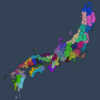
Now compare that with the generalized but perfectly correct province map in Ran no Jidai.

Say you're the Mori clan. Your number of fiefdoms (kuni) is five including the islands, but you have a single province (in red in the second map) and a tough start position. Now you certainly couldn't have 350-360 regions as 200 is the max, but doubling the number would spread out the income production. All of those wouldn't be filled with dojo, that would be silly, but all would have agriculture, ports, and markets, and hence generating income from numerous streams of trade, intra-trade from each kuni, then inter-trade between provinces. See the problem?
I've been thinking about this for the last 24 hours. The boosting of the tax and trade income that I've been modding in the EDB is really traced back to this issue.
Militarily, the placement of many forts in each province could replicate these fiefs. Then effectively eliminate making new "fiefs" as forts by making the price enormously high. You can preplace forts in the descr_strat, so that's not an issue. Having lots of forts, with the rebel spawning as they do, then demonstrates the vital importance of garrisons along these strategic points. Otherwise, as happened in history, bandits could prey upon fiefs that were hard to get to logistically.
The road networks are minimal in RTW1. The way the roads are drawn up is a function not done by the mapper, but hardcoded by the placement of cities and ports, then the RTW engine places the roads mostly automatically by calculating the minimal distances versus terrain and bypassing rivers and mountains and some forests. This actually is quite correct for Sengoku era Japan, because in the interior of the country, say the mountain regions, then bandits could easily prey upon those villages, and it would take too long to go from point a - to point b to point c to point d etc for many links before finally arriving at the village. See?
That meant that fiefs had to have some centralized garrison so that they could be deployed from a hub, almost certainly a city of some size. The way the engine works, you can't have multiple cities within a settlement, only increase settlements to display those cities, one for one.
However, if the wooden fort model is named the same, but the strat model is changed, and the settlement plan is substituted for say the large town, then it's theoretically possible that some preplaced mock-settlements as large towns would appear on the map, just not be named. They wouldn't grow. They would in effect be forts that would never be built, only preplaced.
Now the question I'm pondering is if I manage to successfully increase the economy to something approaching historical levels, then maybe the Mori would have ONE initial province per the regular map, but four more "forts" that appear as large towns within their province. Then by replacing the "fort" settlement plan, then maybe a large town battlemap would appear at that map coordinate. In effect the Mori would initially have five defensible towns, BUT only one province to grow.
Last edited by RubiconDecision; July 02, 2016 at 09:05 AM.
-
July 03, 2016, 09:21 AM
#2
Re: A Fiefdom Kuni Map of Sengoku Era Japan
Here's an example of the kuni or han i.e. fiefs which comprise the provinces of Sengoku era Nippon.
https://en.wikipedia.org/wiki/List_of_Han
Each han is broken down on that page, but of course not all have wiki pages. But each is listed though of course there were name changes over time.
Example: Satsuma is a province on Kyushu, and within that province is an unusual situation since they had absorbed the Ryuku Kingdom's island domains, first diplomatically so not to disrupt the trade through to the Ming, but later in actuality and converting the pechin (at the urging of the former King) to samurai.
Example: Hyuga is a province on Kyushu, and within that province are Nabeoka, Takanabe, Sadowara, and Obi.
-
July 03, 2016, 12:10 PM
#3
Re: A Fiefdom Kuni Map of Sengoku Era Japan
As far as I know, the best map showing the han (fief) borders with any reasonable accuracy is this attachment. However it was created for a computer strategy game but used the incorrect fief names. What a shame.
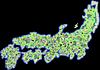
Which means you'd have to transpose the actual names from the Wiki link above.
Now I don't believe you can name forts in RTW. Gigantus figured out a way to use princess agents in MTW2 to display that. But it would be cool to simply place the forts within the correct fief borders, not even attempting to get the actual location correct, for that's too difficult to research, but merely making the fort be in logical logistically beneficial map coordinate in the descr_strat such that it facilitates the leap frogging of moving samurai from point a to b to c as would have happened with limited roads of the Sengoku Era.
Side note: Japan is an ancient nation, and the rapid urbanization resulted in a hodge-podge of construction that persists to the 21st Century. Even today, taxi drivers insist upon directions because the roads were built in a haphazard order based upon pressing need...not planning in a grid manner, nor the Spanish method of directional roadways, but you can have a bewildering series of roads that lead no where, and the only exit is back the way you entered.
In the 16th and 17th century, such poor roads would have easily led to being ambushed in cities in blind section, or caused confusion as travelers made their way. Which is why a mass of travelers on foot or horseback or pallaquin would follow everyone else. There were no direct ways to get from two points without often going through a series of stops...which greatly lengthened the travel time.

The cartographers for the EU3 game and Sengoku:Way of the Warrior made some of the most accurate maps of these han (fief) which you can see when zooming in, BUT no one has ever assembled this in an overhead view so you can see all of them with their borders and names at-a-glance. That is a tragedy and would be a marvelous resource that no history site has. It's probably in some dusty tome in some library somewhere, but not available online anywhere...and I've been looking for one. It's one of the best aspects of EU3 and Sengoku...though I loathe those games due to their dearth of accuracy about combat.
...
One could place custom tiles within these han borders and delightfully could have a village here, a town there, a large town elsewhere, and so forth, versus the method I'm describing in which a newly defined "fort" would be the same everywhere it was designated in the descr_strat.
Which would be terrific and diverse, but it's my understanding that there are limitations as to how many of those custom tiles the engine will allow as it builds the map. I think it's something like only 16 custom tiles, so that would be cool, and you could mix and match them.
OR another idea would be that the "forts" are villages at the lowest level, cost 3,000 ryo, and could be built anywhere. So instead of a wooden fort battle, one would have lots of village battles which would be more nuanced than a fort battle, and allows the creation in-effect of new STATIC villages (they won't grow or change), but you could probably do some creative trait where it somehow reduced the growth of the settlement.
Roma Surrectum roleplayed that in the EDB by having a suburb project for reducing growth in stages, and making it beneficial to do so (so the AI does it), and therefore not max out citizens in the settlement but in-effect relocate the citizens to the countryside. Then doing so would result in the governor getting traits, or gifting these beneficial traits (as urban planners) to the AI.
In Civ 5, someone made a Sengoku mod, and that map is extraordinary. How I wish we could do this in RTW because then one could carefully chose the terrain upon which to fight. The map in Ran no Jidai is great, but the elevations on the strat map versus the battle map vary.

Last edited by RubiconDecision; July 03, 2016 at 12:37 PM.
-
July 05, 2016, 06:44 PM
#4
Re: A Fiefdom Kuni Map of Sengoku Era Japan
Though I presume the most pressing need is to add in Korea for an Imjin War simulation, it seems to me that some han might be added in as official settlements based upon their importance. Others would be merely custom tiles and seen when battle is resolved on that map coordinate. Others could be represented as designated forts, but there might be different kinds of forts for different cultures.
Doing this might then depict the han (fief) system more correctly, facilitate movement rates, and then comprehensively solve some of the puzzling logistical aspects of Ran no Jidai to make it historically accurate as best as possible. Large kuni (provinces) would most benefit as some provinces are quite small. But then this major change makes the Date and the Uesugi suddenly have many more settlements.
It seems like to submod this, the map is the most important aspect to deal with first, as 95% of RNJ is terrific, even spectacular.
The large generalized Japan map in post three showing these han designations is not radically different than RNJ. It perhaps would add twenty more han, something that I thought to do through custom tiles alone rather than change the map/settlements. Then they're not much different than "forts" whatever those forts end up being. That's very historically accurate because they're called "castle-towns" by historians, for people moved in to act as artisans, merchants, servants, etc around castles, making it a necessity to have a village there at the "fort" and then these grew over time to become regular cities (but that was beyond the Sengoku time period).
Last edited by RubiconDecision; July 05, 2016 at 06:55 PM.
 Posting Permissions
- You may not post new threads
- You may not post replies
- You may not post attachments
- You may not edit your posts
-
Forum Rules


 Reply With Quote


