It is unnecessary, as it doesn't make it anywhere better or more interesting, it's like you have a perfect cake and you put ketchup on top of it because people that eat the cake also like fries.Originally Posted by Spectre48


It is unnecessary, as it doesn't make it anywhere better or more interesting, it's like you have a perfect cake and you put ketchup on top of it because people that eat the cake also like fries.


")
")

Well I disagree with most of the interpetations here. If you cross reference Middle earth with history, there is a few patterns to be seen. Middle Earth as far as I can deduct is placed roughtly in the technological spectrum of the dark ages 500 ad to 900 ad. Save for the Hobbits who are more like 1700's rural england.
Firstly, Gondor is analogous to Byzantium, not Italy. Byzantium was the remains of a great empire where only the eastern part still held storng, just like Gondor. Which makes Osgiliath Constantinople, built on the devide on east and west on the bosperos straight/anudin. Which makes Italy Rohan actually. Which at this time was inhabited by the Lagobards, a Germanic people from the North. In tolkiens works the Rohirrim was Anglo-Saxon, but the Legobards were close cusins of the Anglo-Saxons.
As for Arnor, yeah England is a good fit as well as most of France. Previously occupied by the Numenorians but abandoned. Just like England and France was occupied by the Romans and by this time it was abandoned and the Roman Empire only existed in Byzantium (Gondor). I guess hobbitun would be places somewhere in northern England.
The fantasy races is nowhere specific considering they have no hisorical counterparts. They are mostly drawn from Norse mythology. I suppose you can make the alps the misty mountians. Dale and the Northmen could possibly be Germany/Scandinavia. At this time Germany and Sweden was heavily forested.
As for the Evil factions, The Corsairs of Umbar and Haradrim are pretty obvious counterparts to arabs in the middle east and the African north coast (Corsairs of Umbar were former Numenorian colonies, similar to the Corsairs of North Africa were previously Roman terretory in North Africa, see it works!) while the Rhun would be turks I guess. As for the Variags, that is a name used for the Rus Varangians. I also think they are described as grim axemen in the Return of the King. So the Kievan Rus is the best bet. The Vainriders should then be peshengs or some other nomadic steppe tribe.
As for mordor? The Black Sea, Right next to Gondor
Last edited by Påsan; September 06, 2015 at 03:31 AM.
As far as I recall, Tolkien repeteadly denied those claims even when people always related the books to WWII (it said so in my LOTR extended edition books)


")
")
")

")
")
")
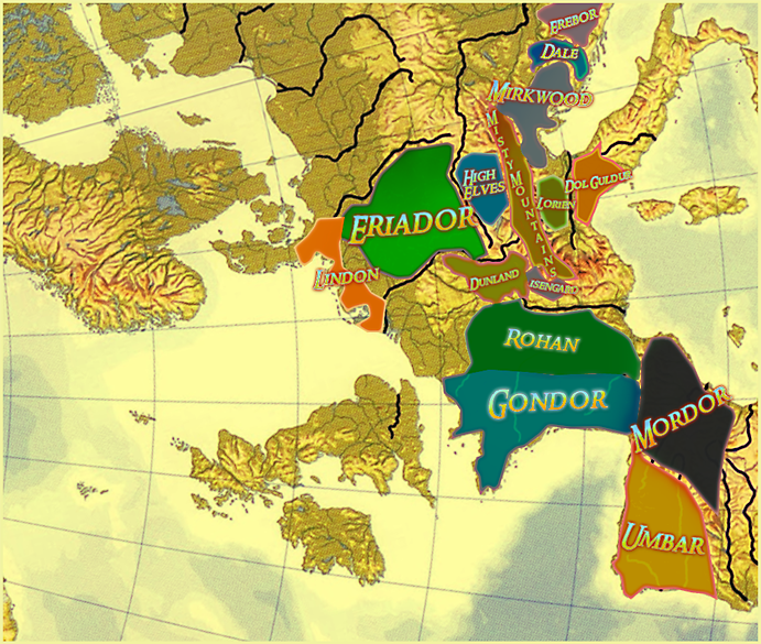
I have also made my own map of Middle-Earth based on Europe:
It was quite quickly done and didn't go into detail much. Wasn't sure how to include Harad or Rhun.
Son of MasterBigAb; Father of St. Polycarpe Kahvipannu Radboud Mhaedros GeMiNi][SaNDy
Flinn UndyingNephalim KAM 2150 Charerg


")
")
")
")


")


lol, I live in Dol-Amroth then
edit: or in the brown lands .. nono, Dol-Amroth is much better
besides, obviuosly Tolkien took inspiration from real world, but with all the due respect I think that trying to "apply" a map of the ME to the Europe is pretty useless, unless of course one wants to do some sound speculation, which is pretty fine in any case
For a italian like me, the references between Romans and Numenoreans are pretty plain, like many others in the book (mongols/easterling for instance); out of my imagination I can say that Tolkien not only took inspiration from such events, but that he also included them as a sort of reference, to build up some easy similarities between real world and ME, as he implied that Ea is nothing but the Earth at its beginning.
Last edited by Flinn; September 07, 2015 at 08:22 AM.
Under the patronage of Finlander, patron of Lugotorix & Lifthrasir & joerock22 & Socrates1984 & Kilo11 & Vladyvid & Dick Cheney & phazer & Jake Armitage & webba 84 of the Imperial House of Hader
Have not seen the video yet (i am a little busy these days but before seeing it (yet), my feeling would be like what Dude says.
Umbar should be an Arab area, so it doesn't fit in a mixed celtic/iberian area such as Galicia (North West Spain). Due to the mix of races of the Numenoreans with "lesser men" in Pelargir area (more or less) it could represent the racial mixture europeans/arabs/jewish in Spain. Gondor needs to be IMO France/Italy.
Last edited by ElvenKind; September 13, 2015 at 01:11 PM. Reason: posts merged
Gondor has always to me felt like a combination of Greece, Byzantium, Constantinople/Istanbul and the Balkans as the many fiefdoms.

HAHA! I live in Mirkwood..
American, French, Israeli and British government's ILLEGAL aggression against the Syrian people, without any proof for chemical attacks in Douma, and without waiting for OPCW to conduct their investigation..
Sons of *******, leave that poor, war torn country in peace.
If you are a citizen of one of these countries, then DO NOT ask any help from me on these forums, since, in protest against this aggression by your governments, I do not provide assistance/help anymore.
Let Syria be finally in peace.
A video of false chemical attack in Douma, Syria, which led to Western illegal attacks.
LOL. Greece is Harad and Mordor. I knew it all along!
 dutch speaking

")
")
ah hence the wolfshead evil servant of sauron I will kill you
and you dare to bear the name of the childeren from my people
Rise of Mordor 3D Modelers Wanted
Massive Overhaul Submod Units!
Under the proud patronage of
Frunk of the house of Siblesz
R_V, you are looking at the map from a wrong angle..
Umbar and Mordor are actually Spain.
My avatar is always hungry.. So don`t tease the Wolf.. Especially an alpha Wolf.
American, French, Israeli and British government's ILLEGAL aggression against the Syrian people, without any proof for chemical attacks in Douma, and without waiting for OPCW to conduct their investigation..
Sons of *******, leave that poor, war torn country in peace.
If you are a citizen of one of these countries, then DO NOT ask any help from me on these forums, since, in protest against this aggression by your governments, I do not provide assistance/help anymore.
Let Syria be finally in peace.
A video of false chemical attack in Douma, Syria, which led to Western illegal attacks.
I think he must be writing about one of the earlier maps of the thread, first post:
Although in this case it's Harad but not Mordor.
I agree with this analogy. Byzantium was the shadow of the glorious Roman empire...similar to Gondor being the remnants of Arnor. The byzantines (gondor) for many years held against the various eastern invasions including persians, seljuks, ottomans etc.The massive numbers of the lightly armoured orcs reminds me of the medieval Europe view on arab speaking (muslim) populations of that time (while in many cases medieval muslim kingdoms were far more advanced that most of european kingdoms at least till enlightment). And Constantinople (Osciliath) as mentioned above is the last choke point that the byzantines defended after anatolia-asia minor (east osciliath) fell to the ottomans (Mordor). The Ottoman empire was one of the most succesfull empires with several client states including Egypt (easterlings????) and at constant conflict witht the rest of the europe after the fall of Constantinople. The most notable war was against Hungary(Mayars) famous for their cavalry (Rohan??)
I actually updated this, but never posted the update in this forum. For those who were/are still interested, here was the updated version of my maps:
Spoiler Alert, click show to read:
dutch speaking
big work thanks for sharing
greetings atthias
Rise of Mordor 3D Modelers Wanted
Massive Overhaul Submod Units!
Under the proud patronage of
Frunk of the house of Siblesz
Mordor is Anatolia and Bosporus is the Black Gate.
 Posting Permissions

 Reply With Quote