Results 1 to 12 of 12

Thread: Campaign Map Research: The Iberian Peninsula

  1. #1
    Landil's Avatar Tiro
    Join Date
    Jun 2005
    Location
    Somewhere in my Fantasy
    Posts
    246

    Default Campaign Map Research: The Iberian Peninsula

    With the commencement of the Open Beta in the near future, I will be starting a thorough study of the various factions of the Iberian Peninsula: the Kingdoms of Aragon, Castille and Portugal, and the various Muslim Taifas, to find and correct any inconsistencies, to add as much historical content to its cities and castles as possible, and to represent its geographical, demographical and economical structure as realistically as I can.

    I would like to ask all of you to participate in this huge project, to provide me with material on various subjects so that I don't have to search for it myself and so reduce the tediousness of the project for me and increasing (hopefully) the fun for you.

    Now here are some guidelines:

    • A summary of your own research is preferred over just giving me links, though any links to articles are also welcome.
    • When you post your research, please give me the links to the sources you used as well. I cannot use research lacking references, as I need to check its validity!
    • I would prefer if you kept your linked sources to the English, German and Dutch languages, as I can read those.
    • If you have good sources in other languages that are native you, a PM with a full translation into English would be most welcome!
    • The priority for this project is information on cities and castles.
    • Please note that the older the settlement, the more likely it is to be added. A settlement that had already existed for a long time by our starting date of 1080 AD is much better than a city that was founded in the 14th century, even though that is still within the period covered by DotS.
    • Similarly, the larger and/or more important the settlement, the better. We have limited amount of space on the map, so don't bother giving me information on every little village that existed.
    • The best information you can give is obviously a summary of the settlement's history in the period of 1080-1453 AD and also the Middle Ages prior to 1080.
    • Some figures that are of great use to me: exact coordinates of the medieval location (some places have moved from their medieval location, always check if this is the case), settlement's foundation date, when the settlement received certain rights (city rights, joined the Hanseatic league, became a bishopric, became a county's capital, etc.).
    • Others things I'm interested in: the presence of ethnic/religious minorities (Jews, pagans, etc.), economical activities (trade, agricultural and artisanal production, etc.), political affiliations (to what county/bishopric/etc. does it belong? was it rebellious?), heraldry of the city/castle and/or its direct lord (a picture or a link to a picture).
    • Any information on geographical features that were different from what they are now (the old courses of rivers and such). Detailed maps are of great use here.
    • Any information on the economical facilities of a region, such as fertility (arable land and such), industrial works such as mines and quarries, and artisanal produce like glass, timber, and weapons. Please specify how important the production was in comparison to other products of the region and to the production of other regions.

    Please try not to deviate from these guidelines, as almost all content that does not fit into these parameters will be useless to me, and as such a waste of your time. If you're not certain you're doing it right, feel free to ask me for help either in this thread or in a PM!

    Also, please post your research on this subject in this thread, do not make your own threads about it. I want to keep this as organised as possible, so please adhere to this rule, and please keep your posts neat and mature. Thank you!

    Lastly, I want to wish everyone good luck on their research, your contributions mean a lot to us! And remember: anything is useful, no matter how little it is!

    Cheers,

    Landil, Mod Leader and Head of Research for Dominion of the Sword
    Last edited by Landil; January 13, 2014 at 07:14 PM.
    Mod Leader, Head of Research & Middle East Specialist

  2. #2

    Default Re: Campaign Map Research: The Iberian Peninsula

    Suggestion of new PSF's to Portugal:

    Coimbra Province


    Guimarćes

    Foundation(or Foral): 1096
    Coordinates: 41° 26′ 27″ N, 8° 17′ 41″ W (Historical centre of Guimarćes)
    Localization:
    Spoiler Alert, click show to read: 


    Carrazeda de Ansićes
    :

    Foundation(or Foral): 1075
    Coordinates: 41° 12′ 9.93″ N, 7° 18′ 19.95″ W (Castle of Ansićes)
    Economy: Vineyards, Small agricultural villages.
    History:
    Spoiler Alert, click show to read: 
    The first remnants recorded on this site date to the Chalcolithic period approximately 3000 B.C.E., and were the basis for the early Roman settlement that developed. This ended with the sack of Carrazeda de Ansićes by northern barbarians in 409.

    This was followed by the conquest of the region by Muslim forces in 711. The settlement escaped attacks by the Leonese forces during the 11th century, but, its position near Christian kingdoms meant that a fortification was required to protect their settlement. Yet, by 1057, the first Christian foral (charter) was instituted by the Ferdinand I of León and Castile, insinuating the fall of the Moorish fortress; the foral constituted one of the oldest geographic forals, defining the extent of Portuguese borders. During the High Middle Ages, the location already possessed a long cultural heritage, a factor that allowed it to become a fulcrum along the Douro River. Consequently, in subsequent centuries, the region experienced an exponential growth within the walled settlement.

    In 1160, Afonso Henriques conferred the first Portuguese foral, later validated on 6 April 1198, by his successor King Sancho I, and again in April 1219, by King Afonso II.The village progressively imposed its importance in the territory it belonged, which included diverse resources, a prolifieration of small agglomerations and agricultural parcels. It was in this context that in 1277, King Afonso III issued a charter to allow a fair in Ansićes.

    King Ferdinand gave the town of Carrazeda de Ansićes to Joćo Rodrigo Porto Carrero, in 1372. But, Joćo Rodrigues took-up arms for the Kingdom of León and Castile, which would only be settled in the Treaty of Badajoz in 1382.

    Between 1384 and 1496, a letter in the localities of Freixial, Murēa and Abreiro obligated the transfer of customs dues to the construction of the new castle. But, in order to quicken the construction these funds were supported by the church funds. In 1443, the regent Peter funnelled the taxes from Freixiel, Abreiro and Vilarinho da Castanheira to support the repair of the walls of the castle.

    Confirmation of the Floral also includes the first definition of the term Ansićes comprising a geographical area located "per littore Dorio de cabeza de requeixo usque in fraga de azaiam et per portela de mauro usque in cima de ualle de torno cum suas teleiras usque in cruce de freisinel. "

    The first territorial extension reveals the increasing consolidation of urban importance that the village had throughout the Middle Ages. But is that the Middle Ages Ansićes imposes itself strategically in an area central to the Christian expansionism, thus acquiring a status urban reaches its climax during the thirteenth and fourteenth centuries.

    The village imposes progressively as the head of a territory that covers an area of diverse resources and where they proliferate and couples agricultural villages.


    Localization:
    Spoiler Alert, click show to read: 


    Sćo Joćo da Pesqueira

    Foundation(or Foral): 1055
    Coordinates: N 41.14817 W 7.40347 or 41° 8' 53.42"N, 7° 24' 12.50"W (Rua dos Gatos, foundation place)
    Localization:
    Spoiler Alert, click show to read: 


    Note: In Portugal, the Foral was the basis for municipal foundation, thus the most important event of a city or town's history. It was critical to a successful land settling and an increase in crop yields, by giving more freedom and dignity, via a concession, to farmers, in an age when people were subject to near slave work, as servants of landlords. The Foral made a concelho free from feudal control, transferring power down to a neighbours council (concelho), with its own municipal autonomy. As a result, the population would become directly and exclusively under the dominion and jurisdiction of the crown, excluding the Lord from the power hierarchy. The Foral granted public lands to the collective use of the community, regulated taxes, tolls and fines and established protection rights and military duties within royal service.


    More suggestion of PSF's and details , such history, economy of each PSF soon.
    Last edited by Dom Pedro II; August 07, 2012 at 04:24 PM. Reason: Spelling corrections

  3. #3
    Landil's Avatar Tiro
    Join Date
    Jun 2005
    Location
    Somewhere in my Fantasy
    Posts
    246

    Default Re: Campaign Map Research: The Iberian Peninsula

    Cheers mate, good work! Though it would be very useful if you could provide me with the exact coordinates of the PSFs as well (like 38°42'46.84"N, 9°7'57.23"W for the historical centre of Lisbon).
    Mod Leader, Head of Research & Middle East Specialist

  4. #4

    Default Re: Campaign Map Research: The Iberian Peninsula

    Thanks!

    I've found that Carrazeda de Ansićes had a medieval village and a castle.

    History of Castle of Ansićes
    :
    Spoiler Alert, click show to read: 
    The first remnants recorded on this site date to the Chalcolithic period approximately 3000 B.C.E., and were the basis for the early Roman settlement that developed. This ended with the sack of Carrazeda de Ansićes by northern barbarians in 409.

    This was followed by the conquest of the region by Muslim forces in 711. The settlement escaped attacks by the Leonese forces during the 11th century, but, its position near Christian kingdoms meant that a fortification was required to protect their settlement. Yet, by 1057, the first Christian foral (charter) was instituted by the Ferdinand I of León and Castile, insinuating the fall of the Moorish fortress; the foral constituted one of the oldest geographic forals, defining the extent of Portuguese borders. During the High Middle Ages, the location already possessed a long cultural heritage, a factor that allowed it to become a fulcrum along the Douro River. Consequently, in subsequent centuries, the region experienced an exponential growth within the walled settlement.

    In 1160, Afonso Henriques conferred the first Portuguese foral, later validated on 6 April 1198, by his successor King Sancho I, and again in April 1219, by King Afonso II.The village progressively imposed its importance in the territory it belonged, which included diverse resources, a prolifieration of small agglomerations and agricultural parcels. It was in this context that in 1277, King Afonso III issued a charter to allow a fair in Ansićes.

    King Ferdinand gave the town of Carrazeda de Ansićes to Joćo Rodrigo Porto Carrero, in 1372. But, Joćo Rodrigues took-up arms for the Kingdom of León and Castile, which would only be settled in the Treaty of Badajoz in 1382.

    Between 1384 and 1496, a letter in the localities of Freixial, Murēa and Abreiro obligated the transfer of customs dues to the construction of the new castle. But, in order to quicken the construction these funds were supported by the church funds. In 1443, the regent Peter funnelled the taxes from Freixiel, Abreiro and Vilarinho da Castanheira to support the repair of the walls of the castle.

    Confirmation of the Floral also includes the first definition of the term Ansićes comprising a geographical area located "per littore Dorio de cabeza de requeixo usque in fraga de azaiam et per portela de mauro usque in cima de ualle de torno cum suas teleiras usque in cruce de freisinel. "

    The first territorial extension reveals the increasing consolidation of urban importance that the village had throughout the Middle Ages. But is that the Middle Ages Ansićes imposes itself strategically in an area central to the Christian expansionism, thus acquiring a status urban reaches its climax during the thirteenth and fourteenth centuries.

    The village imposes progressively as the head of a territory that covers an area of diverse resources and where they proliferate and couples agricultural villages.
    Photos
    Spoiler Alert, click show to read: 


    Urban Structure
    Spoiler Alert, click show to read: 


    Coordinates of Castle of Ansićes: 41° 12′ 9.93″ N, 7° 18′ 19.95″ W


  5. #5
    Landil's Avatar Tiro
    Join Date
    Jun 2005
    Location
    Somewhere in my Fantasy
    Posts
    246

    Default Re: Campaign Map Research: The Iberian Peninsula

    Great stuff, I think this one will certainly be included, probably as a fortress type of PSF!
    Mod Leader, Head of Research & Middle East Specialist

  6. #6

    Default Re: Campaign Map Research: The Iberian Peninsula

    Maps of iberian peninsula with names of some settlements:

    Spoiler Alert, click show to read: 


    Source: Diario de Leon, Kings of León(asturian dynasty 910-1037).
    Last edited by Dom Pedro II; August 17, 2012 at 02:39 PM.

  7. #7

    Default Re: Campaign Map Research: The Iberian Peninsula

    Map of Portuguese reconquest and names of some settlements:

    Spoiler Alert, click show to read: 
    Last edited by Dom Pedro II; August 18, 2012 at 03:10 PM.

  8. #8

    Default Re: Campaign Map Research: The Iberian Peninsula


  9. #9

    Default Re: Campaign Map Research: The Iberian Peninsula

    Nice map, thank you!

  10. #10
    PedroL's Avatar Citizen
    Join Date
    Aug 2006
    Location
    Portugal
    Posts
    2,333

    Default Re: Campaign Map Research: The Iberian Peninsula

    The Portuguese in the Age of Discoveries c.1340–1665


    Here:
    http://www.ospreypublishing.com/stor..._9781849088480
    Vencerei nćo só estes adversįrios mas quantos a meu Rei forem contrįrios

    MEMBER OF THE IMPERIAL HOUSE OF HADER
    UNDER THE PATRONAGE OF y2day

  11. #11

    Default Re: Campaign Map Research: The Iberian Peninsula

    I knew that ages ago.

    Obrigado.

  12. #12

    Default Re: Campaign Map Research: The Iberian Peninsula

    do you still need info about portuguese cities and castles ?
    maybe i can help...

    info:
    Spoiler Alert, click show to read: 
    braga

    -founded: iron age
    -Saint Ovidius (d. 135 AD) is considered one of the first bishops of the city
    -it was in Braga that Archbishopric of Braga held their councils.
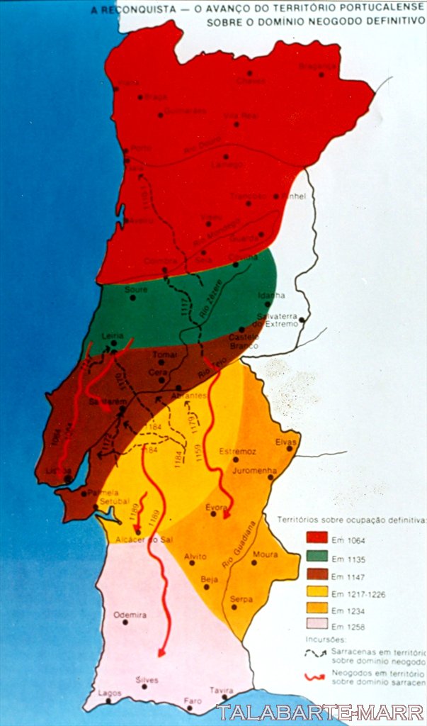
    -The Moors captured Braga early in the 8th century
    -but were eventually repelled by Christian forces under Ferdinand I of León and Castile in 1040
    -Between 1093 to 1147, Braga became the residencial seat of the Portuguese court.
    -the maximum authority in the city was retained by the archbishop.
    -41°32'39?N 08°25'19?W

    http://en.wikipedia.org/wiki/Braga
    http://pt.wikipedia.org/wiki/Hist%C3%B3ria_de_Braga

    porto

    -founded as a city in 417
    -invaded before year 1000 by Abu Amir Muhammad ibn Abdullah ibn Abi Amir (what a lovely name! )
    -was a bishopric
    -1123 – the bishop D. Hugo grants the foral letter to the people of the city
    -income from trading (by sea) was later disputed by kings and bishops
    -during the XIII century the city was in a great expansion period
    -41° 9' N 8° 36' 40" O

    http://www.portoxxi.com/cultura/ver_folha.php?id=22
    http://pt.wikipedia.org/wiki/Hist%C3%B3ria_do_Porto
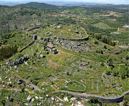

    lamego

    -founded before 201 AD
    -recounquered for the christians in 1057 by Fernando I de Lećo
    -1139, it was were that D.Afonso Henriques (founder of Portugal) was made king by the archbishop of a Braga
    -it was were that sucession laws were established for the kingdom of portugal
    -pop in 1801 of 14.7k
    -41°4'18.07?N 7°49'22.16?W

    http://en.wikipedia.org/wiki/Lamego_Municipality

    viseu

    -founded: iron age
    -1123 foral
    -Viriato was born here
    -in the VIII century muslims conquered it
    - Afonso V died here
    - christians conquered it in 1037 (Fernando Magno)
    - pop in 1801: 33 699
    -40°40'N 7°55'W

    http://pt.wikipedia.org/wiki/Viseu


    coimbra

    -founded: before romans
    -great trading spot (it was between the christian north and the arabic south)
    - conquered by the christians in 1064 by Fernando Magno de Lećo
    -residence of D. Henrique e a rainha D. Tereza
    -birthplace of the first portuguese kingdom, D. Afonso Henriques
    -capital of the coimbra county, and of the portuguese county till 1255
    -40° 15' N 08° 27' O

    buidings:
    -The Old Cathedral of Coimbrais one of the most important Romanesque Roman Catholic buildings in Portugal
    Construction began some time after the Battle of Ourique (1139), when Count Afonso Henriques declared himself King of Portugal and chose Coimbra as capital.
    -Church of St. James
    -Santa Cruz Monastery
    Because the first two kings of Portugal are buried in the church it was granted the status of National Pantheon.
    Founded in 1131 outside the protecting walls of Coimbra, the Santa Cruz Monastery was the most
    important monastic house during the early days of the Portuguese monarchy.

    http://en.wikipedia.org/wiki/Coimbra
    http://en.wikipedia.org/wiki/Old_Cathedral_of_Coimbra
    http://en.wikipedia.org/wiki/Santa_Cruz_Monastery
    Last edited by anonimo272; March 21, 2013 at 01:56 PM.

Posting Permissions

  • You may not post new threads
  • You may not post replies
  • You may not post attachments
  • You may not edit your posts
  •