At around 4 AM we started the trip guided by little GPS device which will later bring us some adventure. Drive to the border with Bosnia was uneventful and dark, as was crossing the border, which I crossed literally a hundred times before.
But shortly after crossing the border my dad (who was driving) and I had a discussion about what road we'll take across Bosnia. GPS wasn't much help, entire Bosnia had only two roads on the map, and both were an option for us. Someone told my dad there is a motorway between Zenica and Sarajevo, so instead of going straight south across Tuzla we turned right towards Doboj and Zenica. This added first extra 30 minutes on what will turn out to be 12 hour trip. If you look at the map above you will notice there is a motorway going through entire Croatia from northeast to southeast. We actually contemplated taking that, twice longer, route because at average 150km/h we would get there sooner.But then there is extra gas to be spent, tolls to be paid and good chance of getting into traffic jams at tolls because it's a middle of tourist season. It was end of July, I forgot to mention.
Also, just as I started the trip, I noticed my camera was broken and had to use the reserve one, which was cheap and ate batteries like fat man eats kebabs. It's useless in dark so I have almost no photos until Doboj. And since I didn't sleep the night before the trip (i'm bad at waking up early) I was fighting too much to stay awake to take photos. Finally, I had too much fun enjoying the landscape to remember taking pictures. So there aren't many from the trip to the coast.
There wasn't much to photograph at start anyway. Northern Bosnia along Sava river is flat lands just like my home region. It's nice enough, clean and no war damages remain. And then it starts becoming hilly until you are in mountains suddenly.


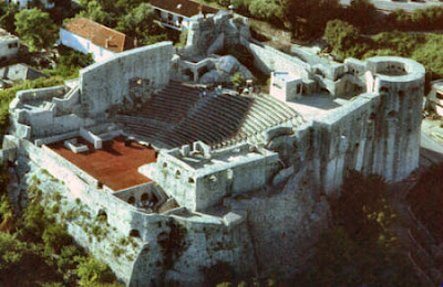
When we reached Doboj my "take pictures you idiot" lamp didn't start yet, I was only trying to photograph a castle on the hill because I once had an argument if it's above Doboj or not.


Doboj is unremarkable enough from the road and we didn't stop there, so I won't bother you with more low quality photos. Apartment blocks mostly. The castle is in fact the
Doboj Fortress which I hope to visit one day, since it's so close.
Here's the panoramic view of Doboj from the fortress from Wikipedia.
After Doboj I actually fell asleep because the road just keeps winding through the mountains on and on forever. There were few towns which I failed to take pictures of, and of
Zenica, one of bigger cities in Bosnia, as well. Zenica is basically like Doboj but without fortress above it. Instead it has huge rusty factories and many more apartment blocks. Most of former Yugoslavian heavy industry was in Bosnia (for strategic reasons: central position and with all the mountains more easy to defend in case of invasion from East or West).
Zenica is also home of most famous prison in Bosnia, place where some war criminals are held and such nice folk. Didn't spot it though.
Anyhow, past Zenica we finally came upon that Bosnian motorway. First as building site, and after few kilometers driving on dirt road, finally the real deal.

Since it's still under construction, there was no toll, or at least it didn't appear to have any until Sarajevo because you could get on and off motorway on many places without paying toll. But after some 20-30 km at the entrance to Sarajevo suddenly toll booths and 2 KM toll (konvertibilne marke -convertible marks = Bosnian currency. Pegged to Euro at 1€ for 2KM, previously pegged to Deutsch Mark at 1:1. In all Croat populated and most Muslim populated parts of bosnia you can also use Croatian Kuna, although they round it up at 4 kn for 1 KM when it should be closer to 3,7 kn as 1€ is 7,4 kn. You can also use Euro everywhere.)
Finally I reached Sarajevo, the city I'm ashamed I never visited in all my years and living only 3 hours from it. And to even bigger shame, I still haven't visited it properly. On the way to the coast we still had a long trip ahead and no time to stop, and on the way back it was too hot to walk the dog out. Yep, I was traveling with my Pug.
I didn't really take any photos of Sarajevo either. This is a poor travel log, I know. But I did on the way back, at least of modern city by the road, as I said I couldn't stop to get to the old center.
But for that I will now flood the post with photos of Hercegovina.
Hercegovina is the other half of the country name, but only the southernmost part of the country and haven't got clearly defined geographical borders. It starts somewhere half way between Sarajevo and Mostar and encompasses everything south of that line.
You know you entered Hercegovina when mountains suddenly stop being green and forested and become more and more rocky and bushy, and climate more Mediterranean. And as road pretty much goes from Croatian border almost to Sarajevo following river Bosna, the road through Hercegovina follows river Neretva.


It looks remarkable, like entire Bosnia, especially to me who lives in the plains. I will cover Hercegovina more when I write on return trip as I was now very tired and struggling to keep my eyes open until we reached Mostar. There we had another dilemma.
The map showed three ways to get to Montenegro. Over Trebinje in east Hercegovina or through Croatia. And you can get to Trebinje on two roads and both go around some big mountain and seem long and probably not in best condition. Oh yeah, I should mention roads all across Bosnia were from decent to good, except the few km's of dirt road where they were building motorway. few years ago I took similar route to Split and they were at best decent. My uncle came to Montenegro from Serbia, but part of the trip was through Eastern Bosnia and Hercegovina across Trebinje and the roads were terrible. Where we went traffic was dense, but there were no jams.
Anyway, i decided it's best to go through Croatia, we can trust the roads will be great and despite certain heavy traffic we get to pass by Dubrovnik, to see it from the hill at least if we don't get to visit it from Montenegro later. Besides, I never traveled through Dubrovnik county of Croatia by road, been there by plane only.
So down we went to Metković. Passed back into Croatia without much waiting on the border. We were supposed to go straight down to the coast and join the Adriatic Highway (Jadranska Magistrala - old two lane road going from Italy to Albania, but wide enough for smooth driving) towards Neum in Bosnia again. But our GPS had other plans.
In center of Metković GPS said to turn right. However the street to the right was pedestrian only. So we go around it through other streets. GPS thinks a little and shows new route. No problem, we thought, let's trust it. After few minutes out of Metković we notice road is very narrow and going into the hills.

it, we thought, let's see where it goes. Half an hour later we're on the top of the hill driving on road not wide enough for two cars and overlooking entire
Neretva delta below us. We pass two tiny villages and then finally after many narrow curves and no other cars on the road we came upon little container house with a single Bosnian border cop. No Croat border crossing at all. First thing he said "GPS?". Everything was clear, we're not the first ones taken here by it. Oh well, he says just move forward and you'll get off the hill in Bosnia.

After equally lengthy and narrow drive on the hill we finally join some bigger road, and then find a sign towards Neum. Yay! Meanwhile, GPS still wants us to go over the mountains. No thanks, this time we'll follow the road signs too. Not that it was anything wrong with taking this road. great views and we've seen some tiny villages in the middle of nowhere which made me wonder what the people there live of? Neretva delta valley is rich agricultural region and there's also tourism, but it's all down the hill. Up here there was nothing but naked rocks. Why would someone want to live there, so far from work and sea? Well, I guess people have their reasons.
The drive o the hill had another great side effect. At one point we ended up on cliff above
Neum, the only coastal Bosnian city.


What you see on the photos here is basically entire Bosnian coastline. The bigger peninsula in the back is Croatia.
Here you can read why Neum originally became part of Ottoman empire, and through it Bosnia. In modern history, post WW2 Yugoslavia defined interrepublic borders mostly based on demographics but in case of multinational Bosnia old Borders from Ottoman and Austrian times were reinstated, making Neum Bosnian, and Dubrovnik county cut off from rest of Croatia.
After Neum we were on, what appeared to me because I was sleepy, a short trip to Dubrovnik by coastal Adriatic Highway.

At one point due to misunderstanding we took a wrong turn and instead of going to Dubrovnik bridge we ended up under it. It was a good mistake, nevertheless.


And from there we also saw the cruiser port of Dubrovnik.

And finally the Jewel of Adriatic itself.


There's nothing I can say about the city which can't easily be found on the internet. It's even more beautiful than I remember. Sadly I didn't go down to the city. I want to, but not so much considering the expense and rivers of tourists. I've been there 15 years ago just after the war when there were much fewer tourists and seen the city in a way no one can see it today. Even then it was packed, now with 4 or 5 cruisers per day and not counting also tourists who stay there, it's too much. It really takes much from experience. Same was and is with Venice, for instance.
After Dubrovnik it was another hour or so to Herceg Novi. It was quite an adventure finding the hotel and all, but that's for the next post, as well as much more pictures. I struggled this entire trip to stay awake but I still had to write something about it. For me the trip itself, traveling between two locations and seeing things through the windshield or train/bus window is half the experience.


 Reply With Quote


")

 will read in more detail tomorrow. In the meantime have some rep


")

 ?
?


