~oh goddamit, just take note to be patient and never send out too many pms at once :laughing: ~
~and for a more interesting read
http://rinkworks.com/dialect/dialect...hp%3Ft%3D39035 ~
Some people have liked my maps, and that's brought me a great deal of pleasure. Many people have congratulated my skill at making such accurate, large, and aesthetically pleasing works of art, but the truth is that they are not works of art, far from it it in fact. They are the product of research and a hobby of mine called geograhical information systems. By converting freely provided satellite data, i could create maps that, with work, could be used to play Rome: Total War. Much of the process used to be very time consuming, and, in some ways, costly. However, with more work, I have found a good freeware tool and some good data so the process can be undertaken by anyone who wants to. Through this process, it is possible to create a good map like the quality I have shown previously in under an hour. It is a very easy to do and anyone can do it and enjoy it.
It all begins with a trip to a United States Geological Survey.
http://edc.usgs.gov/products/elevati...0/gtopo30.html
That website shown above contains GTOP03 data, which is a multinational composite of digital elevation models. This is the raw data that is converted into a tga format that makes this process possible. Download the data into a folder and put all of it in the same folder. Don't unzip the data. The data should be accessed in its zipped format.
Next, we go to a site that provides a good converter for the tool. It is free and easy to use.
http://www.visualizationsoftware.com/3dem.html
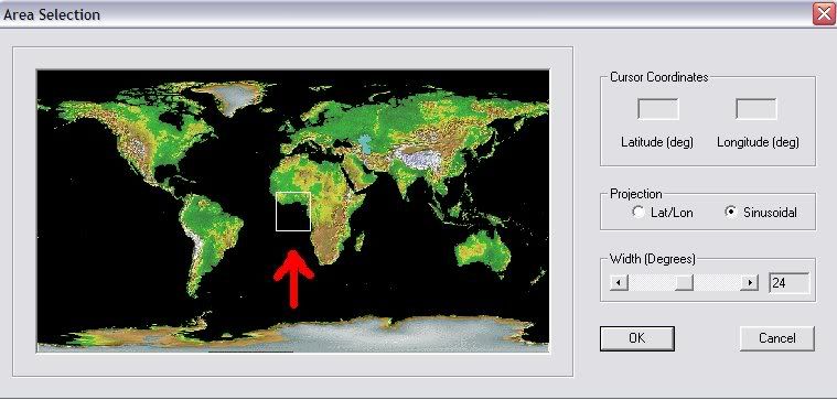
This software is nescessary for converting the data into a useable form. Its also the only good way to do it unless you want to pay for software. Download the software. When you open the software, a small box will pop up asking you what you want to acess. Select USGS dem. Explore your computer for the dem files. Drag a box and select all the data. Another screen with a map will pop up and ask you where you want to go. Drag the bottom bar all the way across. That bar specifies the size of the data area. You can open 20 by 20 degrees of data at a time. Then, select a good area. A digital elevation map of the area will then load. The map though will not be on a black to white color scale. Open the color scale box at the top of the screen and select modify scale. Go through the pallete and change the color scale to a black and white. Its a fairly simple process and only requires a little bit of algebra. Modifying the pallette is also important for creating different elevation effects and playing around with it can help create good maps. You will also see an altitude range. The altitude range specifies the altitude of the area and will be reset to the area's range of altitude every time you load data. In order to create a continous map, modify this so its constant for the places you will connect together. After this, close that box and then open the Geo Coordinates pull down and turn the coordinates off. From there go to File and save map image. Save it as any image file you like. After that go to File and load terrain model. Just press ok. You don't need to load the elevation data again since you already selected it. Go through the map process again, except this time choose a different location. Make that location exactly 20 degrees up or down of the original one you had. Repeat much of the process. Once you have some good map images, load them into photoshop. Since you gathered them at exactly 20 degree intervals, they will match up absolutely perfectly in photoshop. Just use the layer system.
Terrain
http://earthobservatory.nasa.gov/Newsroom/LCC/
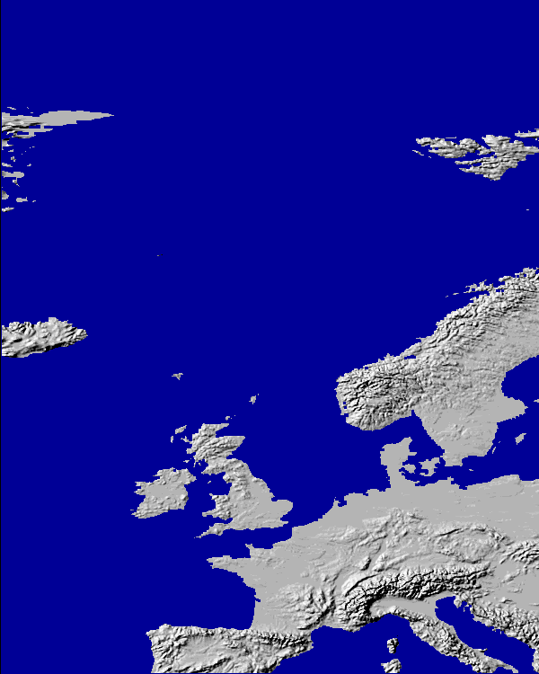
The site above will provide a good base terrain map. It comes in two, extremely large portions. Each pixel should be a discrete datum with no anti-aliasing. If you see anti-aliasing, you've downloaded the wrong file. The files are extremely large so a large amount of ram is helpful when using in photo shop. The terrain data was also made from the GOTP03 data, so in ps, the two will match up absolutely perfectly. Absolutely do not be satisfied with anything less than perfection in matching these two hope. Only very small allowances should be made since this data would undoubtedly be larger than the elevation data you got from the previous process. Once everything is properly aligned together, use the terrain data to correct elevation flaws in the elevation data. Use photoshop layers to do this process. Basically, the terrain data has been corrected while the elevation data has some holes in it below sea level (most notably at the caspian.) After this, use the color key from the site to convert the data. The data can also be used in climate formation.
It must be noted that this data is designed for the modern day, so any good mapper must make allowances as well as make any and all nescessary corrections. Lets not get lazy now!

Also, using large versions of these files and THEN downsizing can help make it more accurate. This is especially important in any warping, projection changes, or rotations.
Projection Changes
This data comes in a straight mercator format. In order to get the desired projection it must be converted. This can easily be done in the photoshop program. Just remember to use large files and to change them together after they have been aligned and the elevation data corrected. Also, add extra data from aroundt the desired area so it looks more natural if you go over the area you specified. For some of the more extreme projection changes, more work is nescessary. The warp function does not allow you to change multiple files at once. There is an easy way to get around this. It is only data, so it is possible to store it as a single alpha channel. Just convert the terrain data such that no two values have the same Red Green or Blue value and convert the water in the elevation data to 0 0 0 (since that value can't be used anyway for the regular terrain) Store the data as a single file and convert the alpha channels to RBG. Then all you can transform it to your hearts content. Making minor changes, or otherwise very major. After that, it is only a simple matter to seperate the two and reconvert them.
This is the basics of employing freeware and standard modding tools (Photoshop) to create a good base for a RTW map. After this though, hard modding work is needed, much still needs to be done by hand. Creative thought is also nescessary in overcoming many of the hardcoded obstacles that can thwart some use of these materials, espesially when creating a map that spans large distances. Good luck using these materials. They are fun to experiment with and, if implemented correctly, they really do pay off. Some mods use the same or similiar technique, try and spot them if you can

Sincerely,
BDH
In a final note, there are a few more tricks, but you can figure them out on your own
and be sure to mention me when you make maps :laughing:


")


")


 Reply With Quote


")